
Topografische Karte Tenkasi
Interaktive Karte
Klicken Sie auf die Karte, um die Höhe anzuzeigen.
Über diese Karte
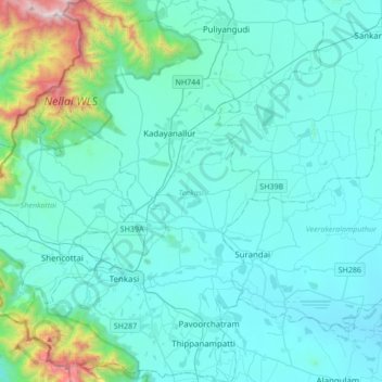
Name: Topografische Karte Tenkasi, Höhe, Relief.
Ort: Tenkasi, Tenkasi District, Tamil Nadu, India (8.86510 77.21419 9.20059 77.42598)
Durchschnittliche Höhe: 297 m
Minimale Höhe: 93 m
Maximale Höhe: 1.880 m
Andere topografische Karten
Klicken Sie auf eine Karte, um ihre Topografie, ihre Höhe und ihr Relief anzuzeigen.
Hosur
India > Tamil Nadu > Hosur
Hosur experiences a tropical savanna climate (Köppen climate classification) with distinct wet and dry seasons. Due to its high elevation, Hosur usually enjoys salubrious and moderate climate throughout the year, with occasional heat waves. The coolest month is January with an average low temperature of 17.1…
Durchschnittliche Höhe: 859 m
Mayiladuthurai
India > Tamil Nadu > Mayiladuthurai
Mayliladuthurai is situated at a distance of 281 kilometres (175 mi) from Chennai and 122 kilometres (76 mi) from Tiruchirappalli. The town is located at 11°06′N 79°39′E / 11.10°N 79.65°E / 11.10; 79.65. Situated at a distance of 24 kilometres (15 mi) from the Bay of Bengal coast, the town is…
Durchschnittliche Höhe: 10 m
Kolukkumalai
India > Tamil Nadu > Bodinayakanur
Kolukkumalai is a small village/hamlet in Bodinayakanur Taluk in the Theni district of the Indian state of Tamil Nadu. It is home to the highest tea plantation in the world with the tea grown here possessing a special flavour and freshness because of the high altitude. It is located near Munnar in Idukki…
Durchschnittliche Höhe: 1.726 m
Virudhachalam
India > Tamil Nadu > Virudhachalam
Virudhachalam is located at 11°30′N 79°20′E / 11.50°N 79.33°E / 11.50; 79.33. It has an average elevation of 45 m (148 ft).
Durchschnittliche Höhe: 44 m
Valparai
India > Tamil Nadu > Valparai
Valparai is located at 10°22′N 76°58′E / 10.37°N 76.97°E / 10.37; 76.97. It is a mid-elevation hill station (Ootacamund is considerably higher) and has an average elevation of 3,914 feet (1,193 m). It is close to the border with Thrissur district of the Kerala state.
Durchschnittliche Höhe: 1.127 m
Chengam
India > Tamil Nadu > Chengam
Chengam is located at 12°18′N 78°48′E / 12.3°N 78.8°E / 12.3; 78.8. It has an average elevation of 272 metres (892 feet). Chengam municipality is located on the Pondicherry – Thiruvannamalai – Bangalore route, at a distance of 34 km from Thiruvannamalai.
Durchschnittliche Höhe: 276 m
Vaniyambadi
India > Tamil Nadu > Vaniyambadi
Vaniyambadi is located at 12.6872° N, 78.6303° E. It has an average elevation of 354 metres (1,161 ft) and lies in the Eastern Ghats region and on the banks of the Palar river. Yelagiri and Javadi Hills are located to the south of the town. By road Vaniyambadi is surrounded by Ambur and Tirupathur which are…
Durchschnittliche Höhe: 371 m
Dharapuram
India > Tamil Nadu > Dharapuram
Dharapuram is located at 10°44′N 77°31′E / 10.73°N 77.52°E / 10.73; 77.52. Dharapuram town is situated along of the bank of Amaravathi River which flows from the south to north. Uppar River and dam, Nallathankal River and dam, Palar join the river Amaravathi. It has an average elevation of 45…
Durchschnittliche Höhe: 252 m
Aravakurichi
India > Tamil Nadu > Aravakurichi
Aravakurichi is located at 10°46′N 77°55′E / 10.77°N 77.92°E / 10.77; 77.92. and has an average elevation of 174 m (571 ft). The town is located off the Varnasi - Kanyakumari National Highway 7 (India). The time zone is IST (UTC+5:30).
Durchschnittliche Höhe: 171 m
Thengapattinam
India > Tamil Nadu > Vilavancode
Thengapattanam is located in the South western coast of India bordering the Arabian Sea to the west, western ghats to the north, and vast fertile plains with intermittent Rocky hills to the east. The town is 11 km into the Tamil Nadu border from Kerala. The Kerala state capital Thiruvananthapuram is 45 km away…
Durchschnittliche Höhe: 17 m
Tindivanam
India > Tamil Nadu > Tindivanam
Tindivanam is located at 12°15′N 79°39′E / 12.25°N 79.65°E / 12.25; 79.65. It has an average elevation of 58 metres (190 feet). Tindivanam is 120 km (75 mi) southwest from Chennai and 35 km (22 mi) northwest from Pondicherry. Tindivanam is one among the three sub-divisions of Viluppuram…
Durchschnittliche Höhe: 44 m
Sulur
India > Tamil Nadu > Sulur
Sulur is located at 11°01′31″N 77°07′29″E / 11.0254°N 77.1246°E / 11.0254; 77.1246. It has an average elevation of 340 metres (1115 feet). Sulur is regarded as a pleasant town situated very close to the cities of Coimbatore "Manchester of South India" (19 km) and Tirupur (35 km). Thus it…
Durchschnittliche Höhe: 371 m