
Topografische Karte Tathra
Interaktive Karte
Klicken Sie auf die Karte, um die Höhe anzuzeigen.
Über diese Karte
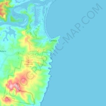
Name: Topografische Karte Tathra, Höhe, Relief.
Durchschnittliche Höhe: 23 m
Minimale Höhe: -4 m
Maximale Höhe: 173 m
Andere topografische Karten
Klicken Sie auf eine Karte, um ihre Topografie, ihre Höhe und ihr Relief anzuzeigen.
Mount Gibraltar
Australia > New South Wales > Bowral
Mount Gibraltar (Aboriginal: Bowrell) is a mountain with an elevation of 863 metres (2,831 ft) AHD that is located in the Southern Highlands region, between Bowral and Mittagong, in New South Wales, Australia. Further west is Berrima.
Durchschnittliche Höhe: 722 m
Prospect Hill
Australia > New South Wales > Sydney
As at 19 February 2001, the Prospect Hill area had state significance due to its unique combination of significant landscape feature, potential archaeological site, and association with important historical phases. As a dolerite outcrop rising to a height of 117 metres (384 ft) AHD , Prospect Hill is a rare…
Durchschnittliche Höhe: 65 m
Sydney Observatory
Australia > New South Wales > Sydney
The place has an association with an extensive array of historical figures most of whom have helped shape its fabric. These include: colonial Governors Hunter, Bligh, Macquarie & Denison; military officers and engineers Macarthur; Barrallier; Bellasis and Minchin; convicts: the as yet unnamed constructors of…
Durchschnittliche Höhe: 14 m
See Park
Australia > New South Wales > Broken Hill City Council > Broken Hill
Durchschnittliche Höhe: 310 m
Mount Banda Banda
Nameplate at the summit of Mount Banda Banda, elevation 1258 metres
Durchschnittliche Höhe: 907 m