
Topografische Karte Ribble Valley
Interaktive Karte
Klicken Sie auf die Karte, um die Höhe anzuzeigen.
Über diese Karte
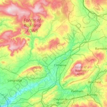
Name: Topografische Karte Ribble Valley, Höhe, Relief.
Ort: Ribble Valley, Lancashire, England, United Kingdom (53.75620 -2.65083 54.04908 -2.18452)
Durchschnittliche Höhe: 200 m
Minimale Höhe: 10 m
Maximale Höhe: 561 m
Andere topografische Karten
Klicken Sie auf eine Karte, um ihre Topografie, ihre Höhe und ihr Relief anzuzeigen.
Brockholes Visitor Village
United Kingdom > England > Lancashire > Preston
Durchschnittliche Höhe: 32 m
Haslingden Grane
United Kingdom > England > Lancashire > Borough of Rossendale
Durchschnittliche Höhe: 305 m
Dowbridge
United Kingdom > England > Lancashire > Borough of Fylde > Treales
Durchschnittliche Höhe: 20 m
Stake Pool
United Kingdom > England > Lancashire > Borough of Wyre > Pilling
Durchschnittliche Höhe: 6 m
Newton-with-Scales
United Kingdom > England > Lancashire > Borough of Fylde
Durchschnittliche Höhe: 16 m
Rishton
United Kingdom > England > Lancashire > Hyndburn
Rishton is situated in an area of low moorland north east of Blackburn and north west of Accrington. Its elevation above sea level varies from 250 feet (76 m) in the east, where Norden Brook flows into the River Hyndburn, to 785 feet (239 m) on Rishton Height, north west of the town.
Durchschnittliche Höhe: 151 m
Accrington
United Kingdom > England > Lancashire > Hyndburn
Geographical coordinates: 53° 46' 0" North, 2° 21' 0" West. Height above sea level: there is a spot height outside the Market Hall which is 133.5 metres (438 ft) the benchmark on the side of the neighbouring Town Hall is 441.10 feet (134.45 m). The highest height in the town is 320 metres (1,050 ft) which is…
Durchschnittliche Höhe: 199 m
Cowm Reservoir
United Kingdom > England > Lancashire > Borough of Rossendale > Whitworth > Shawforth
Durchschnittliche Höhe: 302 m
Ribby
United Kingdom > England > Lancashire > Borough of Fylde > Wrea Green
Durchschnittliche Höhe: 24 m
Roach Bridge
United Kingdom > England > Lancashire > South Ribble > Coupe Green
Durchschnittliche Höhe: 49 m
Deeply Vale
United Kingdom > England > Lancashire > Borough of Rossendale
Durchschnittliche Höhe: 231 m
Scarth Hill
United Kingdom > England > Lancashire > West Lancashire > Ormskirk
Durchschnittliche Höhe: 58 m
Nun Hills
United Kingdom > England > Lancashire > Borough of Rossendale > Stacksteads
Durchschnittliche Höhe: 316 m
Silverdale Green
United Kingdom > England > Lancashire > Lancaster > Silverdale
Durchschnittliche Höhe: 24 m
Forest Holme
United Kingdom > England > Lancashire > Borough of Rossendale > Water
Durchschnittliche Höhe: 318 m
Haslingden Grane
United Kingdom > England > Lancashire > Borough of Rossendale > Haslingden
Durchschnittliche Höhe: 287 m
Trough Gate
United Kingdom > England > Lancashire > Borough of Rossendale > Britannia
Durchschnittliche Höhe: 341 m
Colne Water
United Kingdom > England > Lancashire > Borough of Pendle > Laneshaw Bridge
Durchschnittliche Höhe: 202 m
Fold Head
United Kingdom > England > Lancashire > Borough of Rossendale > Healey
Durchschnittliche Höhe: 294 m
Lower Bartle
United Kingdom > England > Lancashire > Preston > Woodplumpton
Durchschnittliche Höhe: 30 m
Catlow
United Kingdom > England > Lancashire > Borough of Pendle > Nelson
Durchschnittliche Höhe: 243 m
Whitewell Bottom
United Kingdom > England > Lancashire > Borough of Rossendale > Sagar Holme
Durchschnittliche Höhe: 281 m
Rawtenstall
United Kingdom > England > Lancashire > Borough of Rossendale
Durchschnittliche Höhe: 284 m
Old Langho
United Kingdom > England > Lancashire > Ribble Valley > Brockhall Village
Durchschnittliche Höhe: 74 m
Billington and Langho
United Kingdom > England > Lancashire > Ribble Valley > Brockhall Village
Durchschnittliche Höhe: 58 m
Brungerley Park
United Kingdom > England > Lancashire > Ribble Valley > Clitheroe > Waddington
Durchschnittliche Höhe: 77 m
Warton Bank
United Kingdom > England > Lancashire > Borough of Fylde > Warton
Durchschnittliche Höhe: 8 m
Ewood Bridge
United Kingdom > England > Lancashire > Borough of Rossendale
Durchschnittliche Höhe: 226 m
Accrington
United Kingdom > England > Lancashire > Hyndburn
Geographical coordinates: 53° 46' 0" North, 2° 21' 0" West. Height above sea level: there is a spot height outside the Market Hall which is 133.5 metres (438 ft) the benchmark on the side of the neighbouring Town Hall is 441.10 feet (134.45 m). The highest height in the town is 320 metres (1,050 ft) which is…
Durchschnittliche Höhe: 199 m
Bacup
United Kingdom > England > Lancashire > Borough of Rossendale
The geology and topography of the village lent itself to urbanisation and domestic industries; primitive weavers' cottages, coal pits and stone quarries were propelled by Bacup's natural supply of water power in the Early Modern period. The adoption of the factory system, which developed into the Industrial…
Durchschnittliche Höhe: 337 m
Clowbridge
United Kingdom > England > Lancashire > Borough of Rossendale > Habergham Eaves
Durchschnittliche Höhe: 319 m
Haslingden
United Kingdom > England > Lancashire > Borough of Rossendale
Durchschnittliche Höhe: 275 m
Rising Bridge
United Kingdom > England > Lancashire > Borough of Rossendale
Durchschnittliche Höhe: 281 m
Irwell Springs
United Kingdom > England > Lancashire > Borough of Rossendale > Weir
Durchschnittliche Höhe: 365 m
Whittle Springs
United Kingdom > England > Lancashire > Chorley > Wheelton
Durchschnittliche Höhe: 111 m