Geolokalisieren

Topografische Karte Lowertown

Interaktive Karte

Klicken Sie auf die Karte, um die Höhe anzuzeigen.

Über diese Karte

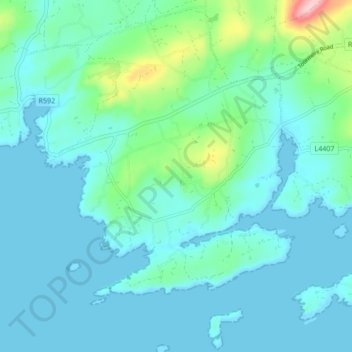
Name: Topografische Karte Lowertown, Höhe, Relief.

Ort: Lowertown, West Cork, County Cork, Munster, Irland (51.48314 -9.64389 51.53591 -9.58401)

Durchschnittliche Höhe: 29 m

Minimale Höhe: -3 m

Maximale Höhe: 190 m

Andere topografische Karten

Klicken Sie auf eine Karte, um ihre Topografie, ihre Höhe und ihr Relief anzuzeigen.

Eastern Division

Irland

Eastern Division, Irland

Durchschnittliche Höhe: 72 m

Dingle / Daingean Uí Chúis

Irland > County Kerry

Dingle / Daingean Uí Chúis, County Kerry, Munster, Irland

Durchschnittliche Höhe: 41 m

Knockanteedan

Irland > County Dublin

Knockanteedan, Glassamucky, Bohernabreena DED 1986, South Dublin, County Dublin, Leinster, D24 T651, Irland

Durchschnittliche Höhe: 243 m

Tara Hill

Irland > County Wexford

Tara Hill, The Municipal District of Gorey — Kilmuckridge, County Wexford, Leinster, Irland

Durchschnittliche Höhe: 77 m

Creevykeel

Irland > County Sligo

Creevykeel, Cliffony North ED, Sligo Municipal Borough District, County Sligo, Connacht, Irland

Durchschnittliche Höhe: 32 m

Carrowkeel

Irland > County Galway

Carrowkeel, Clontuskert ED, Ballinasloe Municipal District, County Galway, Connacht, Irland

Durchschnittliche Höhe: 80 m

The Municipal District of Ashbourne

Irland > County Meath

The Municipal District of Ashbourne, County Meath, Leinster, Irland

Durchschnittliche Höhe: 75 m

Cork

Irland > County Cork > Cork

Cork, County Cork, Munster, Irland

Durchschnittliche Höhe: 79 m

Valentia

Irland > County Kerry

Valentia, Kenmare Municipal District, County Kerry, Munster, Irland

Durchschnittliche Höhe: 39 m

Churchtown

Irland

Churchtown, The Municipal District of Kanturk – Mallow, County Cork, Munster, Irland

Durchschnittliche Höhe: 113 m

Dublin

Irland > County Dublin

Dublin, County Dublin, Leinster, Irland

Durchschnittliche Höhe: 42 m

Limerick

Irland > Limerick

Limerick, County Limerick, Munster, V94 A9NX, Irland

Durchschnittliche Höhe: 54 m

Glencullen ED

Irland > Dublin 18

Glencullen ED, Dublin 18, Dún Laoghaire-Rathdown, County Dublin, Leinster, Irland

Durchschnittliche Höhe: 137 m

Townparks

Irland > Cathair na Gaillimhe > Galway Municipal District

Townparks, St Nicholas, Galway Municipal District, Cathair na Gaillimhe, County Galway, Connacht, Irland

Durchschnittliche Höhe: 7 m

Dublin

Irland > Dublin

Dublin, County Dublin, Leinster, Irland

Durchschnittliche Höhe: 19 m

Dingle - Daingean Uí Chúis

Irland > Dingle - Daingean Uí Chúis

Dingle - Daingean Uí Chúis, County Kerry, Munster, Irland

Durchschnittliche Höhe: 77 m

Ballyman

Irland > Dublin 18

Ballyman, Shankhill-Rathmichael ED, Dublin 18, Dún Laoghaire-Rathdown, County Dublin, Leinster, Irland

Durchschnittliche Höhe: 99 m

North Bull Island

Irland > Dublin

North Bull Island, Raheny St. Assam ED, Dublin 5, Dublin, County Dublin, Leinster, Irland

Durchschnittliche Höhe: 2 m

County Longford

Irland

County Longford, Leinster, Irland

Durchschnittliche Höhe: 73 m

County Dublin

Irland

County Dublin, Leinster, Irland

Durchschnittliche Höhe: 71 m