
Topografische Karte Siargao
Interaktive Karte
Klicken Sie auf die Karte, um die Höhe anzuzeigen.
Über diese Karte
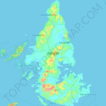
Name: Topografische Karte Siargao, Höhe, Relief.
Ort: Siargao, Surigao del Norte, Caraga, Philippines (9.74487 125.96476 10.06267 126.16865)
Durchschnittliche Höhe: 11 m
Minimale Höhe: -1 m
Maximale Höhe: 249 m
Andere topografische Karten
Klicken Sie auf eine Karte, um ihre Topografie, ihre Höhe und ihr Relief anzuzeigen.
Mount Paco
Philippines > Surigao Del Norte > Paco
Paco is an inactive volcano, 524 metres (1,719 ft) in elevation, located at 9°35.6' North, 125°31.1' East, in the province of Surigao del Norte, region of Caraga, island of Mindanao, the Philippines.
Durchschnittliche Höhe: 386 m
Surigao City
Philippines > Surigao Del Norte
Surigao City is marked by rolling hills that gently buffers its eastern and western boundaries. To the south-west towers the Kabangkaan Ridge which divides the city from the municipality of San Francisco (formerly Anao-aon). Kinabutan River (otherwise known as Surigao River) meanders Surigao valley before it…
Durchschnittliche Höhe: 40 m