
Topografische Karte Fort Collins
Interaktive Karte
Klicken Sie auf die Karte, um die Höhe anzuzeigen.
Fort Collins
Fort Collins is situated at an elevation of approximately 5,003 feet (1,524 meters) above sea level, nestled at the base of the Rocky Mountains in northern Colorado. The city features a varied topography characterized by gently rolling plains that gradually rise to foothills, creating a picturesque backdrop. To the west, the rugged peaks of the Rockies loom, providing stunning vistas and numerous recreational opportunities. The Cache la Poudre River flows through the region, cutting through canyons and valleys, which enhances the area's diverse landscapes. This combination of plains, foothills, and mountainous terrain offers residents and visitors alike a rich environment for outdoor activities and breathtaking scenery.
Über diese Karte
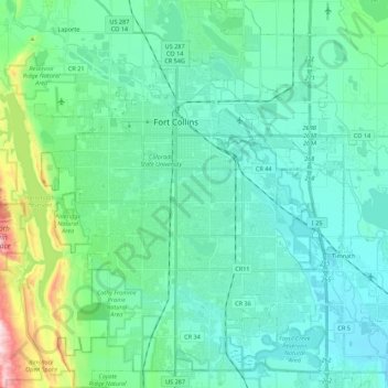
Name: Topografische Karte Fort Collins, Höhe, Relief.
Ort: Fort Collins, Larimer County, Colorado, United States (40.47261 -105.15736 40.63935 -104.98200)
Durchschnittliche Höhe: 1.548 m
Minimale Höhe: 1.462 m
Maximale Höhe: 1.956 m
Andere topografische Karten
Klicken Sie auf eine Karte, um ihre Topografie, ihre Höhe und ihr Relief anzuzeigen.
Estes Park
United States > Colorado > Larimer County
Estes Park sits at an elevation of 7,522 feet (2,293 m) on the front range of the Rocky Mountains at the eastern entrance of the Rocky Mountain National Park. Its north, south and east extremities border the Roosevelt National Forest. Lumpy Ridge lies immediately north of Estes Park.
Durchschnittliche Höhe: 2.543 m
Estes Park
United States > Colorado > Larimer County
Estes Park sits at an elevation of 7,522 feet (2,293 m) on the front range of the Rocky Mountains at the eastern entrance of the Rocky Mountain National Park. Its north, south and east extremities border the Roosevelt National Forest. Lumpy Ridge lies immediately north of Estes Park.
Durchschnittliche Höhe: 2.429 m
Estes Park
United States > Colorado > Larimer County
Estes Park sits at an elevation of 7,522 feet (2,293 m) on the front range of the Rocky Mountains at the eastern entrance of the Rocky Mountain National Park. Its north, south and east extremities border the Roosevelt National Forest. Lumpy Ridge lies immediately north of Estes Park.
Durchschnittliche Höhe: 2.420 m
Horseshoe Lake (South Dam)
United States > Colorado > Larimer County > Loveland
Durchschnittliche Höhe: 1.515 m
Stanley Heights Subdivision
United States > Colorado > Larimer County > Estes Park
Durchschnittliche Höhe: 2.345 m
Estes Park
United States > Colorado > Larimer County
Estes Park sits at an elevation of 7,522 feet (2,293 m) on the front range of the Rocky Mountains at the eastern entrance of the Rocky Mountain National Park. Its location is 40°22′22″N 105°31′09″W / 40.372856°N 105.519136°W / 40.372856; -105.519136. Its north, south and east extremities…
Durchschnittliche Höhe: 2.409 m
Estes Park
United States > Colorado > Larimer County > Estes Park > Estes Park
Durchschnittliche Höhe: 2.461 m