
Topografische Karte Dark Peak
Interaktive Karte
Klicken Sie auf die Karte, um die Höhe anzuzeigen.
Über diese Karte
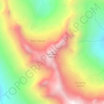
Name: Topografische Karte Dark Peak, Höhe, Relief.
Ort: Dark Peak, Chelan County, Washington, United States (48.25488 -120.88172 48.25498 -120.88162)
Durchschnittliche Höhe: 2.058 m
Minimale Höhe: 1.464 m
Maximale Höhe: 2.637 m
Andere topografische Karten
Klicken Sie auf eine Karte, um ihre Topografie, ihre Höhe und ihr Relief anzuzeigen.
Entiat
United States > Washington > Chelan County
Entiat, Chelan County, Washington, United States
Durchschnittliche Höhe: 376 m
Lake Wenatchee
United States > Washington > Chelan County
Lake Wenatchee, Chelan County, Washington, United States
Durchschnittliche Höhe: 874 m
Plain
United States > Washington > Chelan County
Plain, Chelan County, Washington, United States
Durchschnittliche Höhe: 673 m
Dragontail Peak
United States > Washington > Chelan County
Dragontail Peak, Chelan County, Washington, United States
Durchschnittliche Höhe: 2.235 m
Copper Peak
United States > Washington > Chelan County
Copper Peak, Chelan County, Washington, United States
Durchschnittliche Höhe: 2.032 m
Icicle Creek
United States > Washington > Chelan County
Icicle Creek, Chelan County, Washington, United States
Durchschnittliche Höhe: 974 m
Labyrinth Mountain
United States > Washington > Chelan County
Labyrinth Mountain, Chelan County, Washington, United States
Durchschnittliche Höhe: 1.514 m
Bear Lake
United States > Washington > Chelan County
Bear Lake, Chelan County, Washington, United States
Durchschnittliche Höhe: 1.855 m
Wenatchee
United States > Washington > Chelan County
Wenatchee, Chelan County, Washington, 98801, United States
Durchschnittliche Höhe: 302 m
Sahale Glacier
United States > Washington > Chelan County
Sahale Glacier, Chelan County, Washington, United States
Durchschnittliche Höhe: 2.062 m