
Topografische Karte Gansbaai
Interaktive Karte
Klicken Sie auf die Karte, um die Höhe anzuzeigen.
Über diese Karte
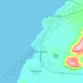
Name: Topografische Karte Gansbaai, Höhe, Relief.
Durchschnittliche Höhe: 34 m
Minimale Höhe: -1 m
Maximale Höhe: 363 m
Andere topografische Karten
Klicken Sie auf eine Karte, um ihre Topografie, ihre Höhe und ihr Relief anzuzeigen.
Hermanus
South Africa > Western Cape > Overstrand Local Municipality
Hermanus, Overstrand Local Municipality, Western Cape, 7200, South Africa
Durchschnittliche Höhe: 87 m
Onrus River
South Africa > Western Cape > Overstrand Local Municipality
Onrus River, Overstrand Local Municipality, Western Cape, South Africa
Durchschnittliche Höhe: 232 m
Betty's Bay
South Africa > Western Cape > Overstrand Local Municipality
Betty's Bay, Overstrand Local Municipality, Western Cape, 7141, South Africa
Durchschnittliche Höhe: 210 m
Stanford
South Africa > Western Cape > Overstrand Local Municipality
Stanford, Overstrand Local Municipality, Western Cape, 7210, South Africa
Durchschnittliche Höhe: 107 m
Boskop
South Africa > Western Cape > Overstrand Local Municipality
Boskop, Overstrand Local Municipality, Overberg District Municipality, Western Cape, 7210, South Africa
Durchschnittliche Höhe: 503 m
Three Sisters
South Africa > Western Cape > Overstrand Local Municipality
Three Sisters, Overstrand Local Municipality, Overberg District Municipality, Western Cape, 7195, South Africa
Durchschnittliche Höhe: 306 m
Kleinmond
South Africa > Western Cape > Overstrand Local Municipality
Kleinmond, Overstrand Local Municipality, Western Cape, 7195, South Africa
Durchschnittliche Höhe: 119 m