
Topografische Karte New California
Interaktive Karte
Klicken Sie auf die Karte, um die Höhe anzuzeigen.
Über diese Karte
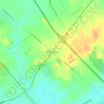
Name: Topografische Karte New California, Höhe, Relief.
Durchschnittliche Höhe: 299 m
Minimale Höhe: 283 m
Maximale Höhe: 318 m
Andere topografische Karten
Klicken Sie auf eine Karte, um ihre Topografie, ihre Höhe und ihr Relief anzuzeigen.
Raymond
United States > Ohio > Union County
Raymond, Liberty Township, Union County, Ohio, 43067, United States
Durchschnittliche Höhe: 324 m
Byhalia
United States > Ohio > Union County
Byhalia, Washington Township, Union County, Ohio, United States
Durchschnittliche Höhe: 314 m
Broadway
United States > Ohio > Union County
Broadway, Taylor Township, Union County, Ohio, 43007, United States
Durchschnittliche Höhe: 314 m
Richwood
United States > Ohio > Union County
Richwood, Claibourne Township, Union County, Ohio, United States
Durchschnittliche Höhe: 288 m
Fleetwood Park
United States > Ohio > Union County > Marysville
Fleetwood Park, Marysville, Union County, Ohio, 43040, United States
Durchschnittliche Höhe: 304 m
Marysville
United States > Ohio > Union County
Marysville, Union County, Ohio, United States
Durchschnittliche Höhe: 308 m
Milford Center
United States > Ohio > Union County
Milford Center, Union Township, Union County, Ohio, United States
Durchschnittliche Höhe: 306 m