
Topografische Karte Bethlehem
Interaktive Karte
Klicken Sie auf die Karte, um die Höhe anzuzeigen.
Über diese Karte
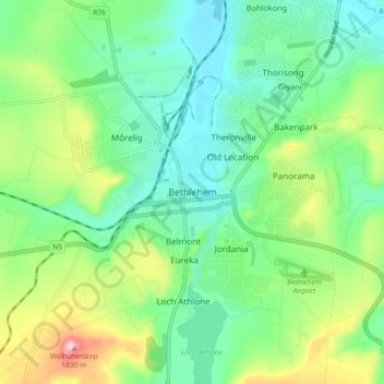
Name: Topografische Karte Bethlehem, Höhe, Relief.
Durchschnittliche Höhe: 1.675 m
Minimale Höhe: 1.605 m
Maximale Höhe: 1.838 m
The city lies at an altitude of 1,700 metres (5,600 ft) and this contributes to its cool climate with frosty winters and mild summers. The average annual temperature is around 14 °C (57 °F).
Andere topografische Karten
Klicken Sie auf eine Karte, um ihre Topografie, ihre Höhe und ihr Relief anzuzeigen.
Sand River
South Africa > Free State > Thabo Mofutsanyana District Municipality > Dihlabeng Local Municipality
Sand River, Dihlabeng Local Municipality, Thabo Mofutsanyana District Municipality, Free State, South Africa
Durchschnittliche Höhe: 1.615 m
Botterkloof Dam
South Africa > Free State > Thabo Mofutsanyana District Municipality > Dihlabeng Local Municipality
Botterkloof Dam, Dihlabeng Ward 11, Dihlabeng Local Municipality, Thabo Mofutsanyana District Municipality, Free State, South Africa
Durchschnittliche Höhe: 1.760 m
Clarens
South Africa > Free State > Thabo Mofutsanyana District Municipality > Dihlabeng Local Municipality
Clarens, Dihlabeng Local Municipality, Thabo Mofutsanyana District Municipality, Free State, 9707, South Africa
Durchschnittliche Höhe: 1.874 m
Fouriesburg
South Africa > Free State > Thabo Mofutsanyana District Municipality > Dihlabeng Local Municipality
Fouriesburg, Dihlabeng Local Municipality, Thabo Mofutsanyana District Municipality, Free State, South Africa
Durchschnittliche Höhe: 1.745 m