
Spenden
Rüste dich für dein nächstes Abenteuer:
Als Amazon-Partner verdient diese Website an qualifizierten Käufen, ohne zusätzliche Kosten für Sie.
Topografische Karte Windermere
Klicken Sie auf die Karte, um die Höhe anzuzeigen.
Spenden
Rüste dich für dein nächstes Abenteuer:
Als Amazon-Partner verdient diese Website an qualifizierten Käufen, ohne zusätzliche Kosten für Sie.
Windermere
There is debate as to whether the stretch of water between Newby Bridge and Lakeside at the southern end of the lake should be considered part of Windermere, or a navigable stretch of the River Leven. This affects the stated length of the lake, which is 11.23 miles (18.07 km) long if measured from the bridge at Newby Bridge,[10] or 10.5 miles (16.9 km) if measured from Lakeside[citation needed]. The lake varies in width up to a maximum of 1 mile (1.6 km), and covers an area of 14.73 km2 (5.69 sq mi).[10] With a maximum depth of 66.7 m (219 ft) and an elevation above sea level of 39 m (128 ft), the lowest point of the lake bed is well below sea level.[10]
Spenden
Rüste dich für dein nächstes Abenteuer:
Als Amazon-Partner verdient diese Website an qualifizierten Käufen, ohne zusätzliche Kosten für Sie.
Über diese Karte
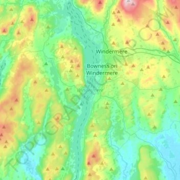
Name: Topografische Karte Windermere, Höhe, Relief.
Durchschnittliche Höhe: 132 m
Minimale Höhe: 3 m
Maximale Höhe: 478 m
Spenden
Rüste dich für dein nächstes Abenteuer:
Als Amazon-Partner verdient diese Website an qualifizierten Käufen, ohne zusätzliche Kosten für Sie.
Andere topografische Karten
Klicken Sie auf eine Karte, um ihre Topografie, ihre Höhe und ihr Relief anzuzeigen.
Storrs
United Kingdom > England > Cumbria > South Lakeland > Bowness-on-Windermere
Durchschnittliche Höhe: 93 m