
Topografische Karte Sirohi
Interaktive Karte
Klicken Sie auf die Karte, um die Höhe anzuzeigen.
Sirohi
Sirohi District is broken up by hills and rocky ranges. The granite massif of Mount Abu divides the district into two portions, running from north-east to south-west. The south and south-east part of the district, which lies between Mount Abu and the main spine of the Aravallis, is mountainous and rugged, and is drained by the West Banas River. Abu Road, a station on the main Delhi-Ahmedabad rail line, lies in the valley of the West Banas. Dry deciduous forest is common in this part of the district, and the higher elevations of Mount Abu are covered in conifer forests. Abu Road is the biggest city and the main financial hub of Sirohi District. Sirohi district has the fewest villages in Rajasthan.
Über diese Karte
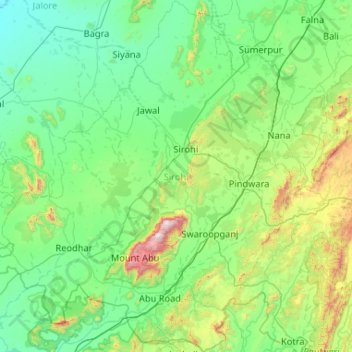
Name: Topografische Karte Sirohi, Höhe, Relief.
Ort: Sirohi, Rajasthan, India (24.33736 72.24644 25.28431 73.17251)
Durchschnittliche Höhe: 351 m
Minimale Höhe: 109 m
Maximale Höhe: 1.678 m
Andere topografische Karten
Klicken Sie auf eine Karte, um ihre Topografie, ihre Höhe und ihr Relief anzuzeigen.
Bikaner
India > Rajasthan > Bikaner Tehsil
Around a century after Rao Bika founded Bikaner, the state's fortunes flourished under the sixth Raja, Rai Singhji, who ruled from 1571 to 1611. During the Mughal Empire's rule in the country, Raja Rai Singh accepted the suzerainty of the Mughals and held a high rank as an army general at the court of the…
Durchschnittliche Höhe: 225 m