
Topografische Karte Алтайские горы
Interaktive Karte
Klicken Sie auf die Karte, um die Höhe anzuzeigen.
Алтайские горы
In the north of the region is the Sailughem Mountains, also known as Kolyvan Altai, which stretch northeast from 49° N and 86° E towards the western extremity of the Sayan Mountains in 51° 60' N and 89° E. Their mean elevation is 1,500 to 1,750 m. The snow-line runs at 2,000 m on the northern side and at 2,400 m on the southern, and above it the rugged peaks tower some 1,000 m higher. Mountain passes across the range are few and difficult, the chief being the Ulan-daban at 2,827 m (2,879 m according to Kozlov), and the Chapchan-daban, at 3,217 m, in the south and north respectively. On the east and southeast this range is flanked by the great plateau of Mongolia, the transition being affected gradually by means of several minor plateaus, such as Ukok (2,380 m) with Pazyryk Valley, Chuya (1,830 m), Kendykty (2,500 m), Kak (2,520 m), (2,590 m), and (2,410 m).
Über diese Karte
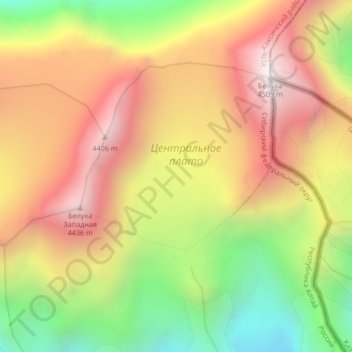
Name: Topografische Karte Алтайские горы, Höhe, Relief.
Durchschnittliche Höhe: 3.898 m
Minimale Höhe: 3.222 m
Maximale Höhe: 4.490 m
Andere topografische Karten
Klicken Sie auf eine Karte, um ihre Topografie, ihre Höhe und ihr Relief anzuzeigen.