
Topografische Karte Upper Saucon
Interaktive Karte
Klicken Sie auf die Karte, um die Höhe anzuzeigen.
Upper Saucon
According to the United States Census Bureau, the township has a total area of 24.6 square miles (63.7 km2), of which 24.5 square miles (63.4 km2) are land and 0.2 square miles (0.4 km2), or 0.59%, are water. Its boundary with Salisbury Township is located on South Mountain. Elevations range from 340 feet (100 m) in Spring Valley to 1,042 feet (318 m) at Bauer Rock atop South Mountain in Big Rock County Park. Upper Saucon is in the Delaware River watershed and is drained by Saucon Creek into the Lehigh River, except for a very small area in the extreme south just southwest of Locust Valley, which is drained by Unami Creek into Perkiomen Creek and the Schuylkill River.
Über diese Karte
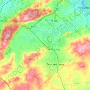
Name: Topografische Karte Upper Saucon, Höhe, Relief.
Ort: Upper Saucon, Lehigh County, Pennsylvania, United States (40.48798 -75.47584 40.58115 -75.33305)
Durchschnittliche Höhe: 175 m
Minimale Höhe: 77 m
Maximale Höhe: 316 m
Andere topografische Karten
Klicken Sie auf eine Karte, um ihre Topografie, ihre Höhe und ihr Relief anzuzeigen.
Center Valley
United States > Pennsylvania > Lehigh County > Upper Saucon
Durchschnittliche Höhe: 152 m