
Spenden
Rüste dich für dein nächstes Abenteuer:
Als Amazon-Partner verdient diese Website an qualifizierten Käufen, ohne zusätzliche Kosten für Sie.
Topografische Karte Monument
Klicken Sie auf die Karte, um die Höhe anzuzeigen.
Spenden
Rüste dich für dein nächstes Abenteuer:
Als Amazon-Partner verdient diese Website an qualifizierten Käufen, ohne zusätzliche Kosten für Sie.
Monument
Monument is situated at an elevation of approximately 7,000 feet (2,134 meters) within the Front Range of the Rocky Mountains, creating a diverse topography that is both striking and varied. The town is characterized by rolling hills and flat terrain in the valley, contrasted by the rugged foothills of the Rockies that rise dramatically to the west. This landscape is further defined by nearby geological features, including Monument Rock, a prominent natural landmark that towers above the area. The surrounding environment includes wooded areas, grasslands, and proximity to the Pike National Forest, making it a hub for outdoor activities such as hiking, fishing, and camping. The mixture of elevations and natural formations offers both residents and visitors stunning vistas and a variety of recreational opportunities.
Spenden
Rüste dich für dein nächstes Abenteuer:
Als Amazon-Partner verdient diese Website an qualifizierten Käufen, ohne zusätzliche Kosten für Sie.
Über diese Karte
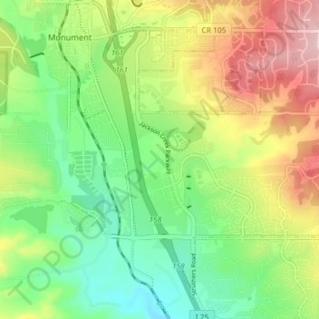
Name: Topografische Karte Monument, Höhe, Relief.
Ort: Monument, El Paso County, Colorado, United States (39.04222 -104.88119 39.09819 -104.84331)
Durchschnittliche Höhe: 2.133 m
Minimale Höhe: 2.035 m
Maximale Höhe: 2.283 m
Spenden
Rüste dich für dein nächstes Abenteuer:
Als Amazon-Partner verdient diese Website an qualifizierten Käufen, ohne zusätzliche Kosten für Sie.