

Topografische Karte Washington County
Klicken Sie auf die Karte, um die Höhe anzuzeigen.
Über diese Karte
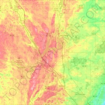
Name: Topografische Karte Washington County, Höhe, Relief.
Ort: Washington County, Wisconsin, United States (43.19214 -88.41920 43.54350 -88.04004)
Durchschnittliche Höhe: 296 m
Minimale Höhe: 202 m
Maximale Höhe: 394 m
Andere topografische Karten
Klicken Sie auf eine Karte, um ihre Topografie, ihre Höhe und ihr Relief anzuzeigen.

Richard Bong State Recreation Area
United States > Wisconsin > Kenosha County > Town of Brighton > Brighton
Durchschnittliche Höhe: 245 m

Blue Mound State Park
United States > Wisconsin > Iowa County > Town of Brigham
Durchschnittliche Höhe: 416 m

Gotham
United States > Wisconsin > Richland County > Town of Buena Vista
Durchschnittliche Höhe: 221 m


Lake Wisconsin
United States > Wisconsin > Columbia County > Town of Lodi
Durchschnittliche Höhe: 242 m

Little Sturgeon
United States > Wisconsin > Door County > Town of Gardner
Durchschnittliche Höhe: 179 m

Horicon Marsh
United States > Wisconsin > Dodge County > Town of Chester
Durchschnittliche Höhe: 262 m

Milwaukee River Floodplain Forest State Natural Area
United States > Wisconsin > Washington County
Durchschnittliche Höhe: 291 m


Observatory Hill State Natural Area
United States > Wisconsin > Marquette County
Durchschnittliche Höhe: 262 m

Dogtown Lake
United States > Wisconsin > Burnett County > Town of Webb Lake
Durchschnittliche Höhe: 299 m
Aspen Lake
United States > Wisconsin > Polk County > Town of West Sweden
Durchschnittliche Höhe: 335 m
Pelican Lake
United States > Wisconsin > Oneida County > Town of Schoepke
Durchschnittliche Höhe: 487 m


Larry Forrest Park
United States > Wisconsin > Saint Croix County > Somerset
Durchschnittliche Höhe: 276 m


Parfrey's Glen State Natural Area
United States > Wisconsin > Sauk County > Town of Merrimac
Durchschnittliche Höhe: 360 m


Land O' Lakes
United States > Wisconsin > Vilas County > Town of Land O' Lakes
Durchschnittliche Höhe: 524 m


Rattlesnake Point
United States > Wisconsin > Crawford County > Town of Marietta
Durchschnittliche Höhe: 232 m


Allenton
United States > Wisconsin > Washington County
Allenton is located at latitude 43.421 and longitude -88.341 at a mean elevation of 958 feet. Allenton has an area of 1.446 square miles (3.75 km2), all land. The Rock River passes through the town.
Durchschnittliche Höhe: 313 m



Pell Lake
United States > Wisconsin > Walworth County > Village of Bloomfield
Durchschnittliche Höhe: 263 m


Northern Wisconsin State Fairgrounds
United States > Wisconsin > Chippewa County > Chippewa Falls
Durchschnittliche Höhe: 279 m


Tahoe Lake
United States > Wisconsin > Lincoln County > Town of Harrison
Durchschnittliche Höhe: 540 m


Wildcat Mountain State Park
United States > Wisconsin > Vernon County > Town of Whitestown
Durchschnittliche Höhe: 310 m


Rib Mountain State Park
United States > Wisconsin > Marathon County > Wausau
Durchschnittliche Höhe: 406 m


Snake Island
United States > Wisconsin > Juneau County > Town of Germantown
Durchschnittliche Höhe: 299 m
Sobieski
United States > Wisconsin > Oconto County > Town of Little Suamico
Durchschnittliche Höhe: 201 m


Erie Street Plaza
United States > Wisconsin > Milwaukee County > Milwaukee
Durchschnittliche Höhe: 180 m


Goll
United States > Wisconsin > Marinette County > Town of Wagner
Goll is located at the intersection of County Trunk Highway X and Old Rail Road (formerly Right of Way Road), at an elevation of 702 feet (214 m). It is connected by road to Wagner to the north, Middle Inlet to the west, and Wisconsin Highway 180 to the east. Goll Road runs obliquely to the east of the former…
Durchschnittliche Höhe: 210 m


Beaver Edge
United States > Wisconsin > Dodge County > Town of Beaver Dam
Durchschnittliche Höhe: 277 m

Spider Island
United States > Wisconsin > Door County > Town of Liberty Grove
Durchschnittliche Höhe: 175 m

Holcombe
United States > Wisconsin > Chippewa County > Town of Lake Holcombe
Durchschnittliche Höhe: 325 m

Lake Adelaide
United States > Wisconsin > Vilas County > Town of Winchester
Durchschnittliche Höhe: 508 m
Gotham
United States > Wisconsin > Richland County > Town of Buena Vista
Durchschnittliche Höhe: 221 m

Calvary
United States > Wisconsin > Fond du Lac County > Town of Marshfield
Durchschnittliche Höhe: 291 m

Black River Falls
United States > Wisconsin > Jackson County > Black River Falls
Durchschnittliche Höhe: 264 m



Hawk Lake
United States > Wisconsin > Oneida County > Town of Lake Tomahawk
Durchschnittliche Höhe: 490 m


Hilton Estates
United States > Wisconsin > Dane County > Town of Bristol
Durchschnittliche Höhe: 296 m
Rattlesnake Point
United States > Wisconsin > Crawford County > Town of Marietta
Durchschnittliche Höhe: 232 m

Yellowstone Lake State Park
United States > Wisconsin > Lafayette County > Blanchardville > Town of Fayette
Durchschnittliche Höhe: 288 m
Sand Prairie
United States > Wisconsin > Richland County > Town of Richwood
Durchschnittliche Höhe: 215 m



George W Mead State Wildlife Management Area
United States > Wisconsin > Marathon County > Town of Bergen
Durchschnittliche Höhe: 343 m

Perrot State Park
United States > Wisconsin > Trempealeau County > Town of Trempealeau
Durchschnittliche Höhe: 223 m


Danbury
United States > Wisconsin > Burnett County > Town of Swiss
Danbury is located at 46.006N. The longitude is -92.371W. It is in the Central Standard Time Zone. The elevation is 938 feet (286 m) above sea level.
Durchschnittliche Höhe: 287 m


Stevens Point
United States > Wisconsin > Portage County > Stevens Point
Durchschnittliche Höhe: 341 m

