
Topografische Karte St. Marys
Interaktive Karte
Klicken Sie auf die Karte, um die Höhe anzuzeigen.
Über diese Karte
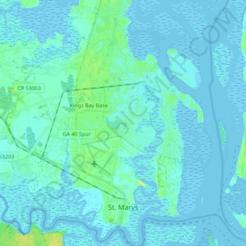
Name: Topografische Karte St. Marys, Höhe, Relief.
Ort: St. Marys, Camden County, Georgia, United States (30.70904 -81.65818 30.84418 -81.50552)
Durchschnittliche Höhe: 3 m
Minimale Höhe: -7 m
Maximale Höhe: 21 m
Andere topografische Karten
Klicken Sie auf eine Karte, um ihre Topografie, ihre Höhe und ihr Relief anzuzeigen.
Kingsland
United States > Georgia > Camden County
Kingsland, Camden County, Georgia, 31548, United States
Durchschnittliche Höhe: 5 m
London Hill
United States > Georgia > Camden County
London Hill, Camden County, Georgia, United States
Durchschnittliche Höhe: 2 m
Woodbine
United States > Georgia > Camden County
Woodbine, Camden County, Georgia, United States
Durchschnittliche Höhe: 6 m
Kings Bay Base
United States > Georgia > Camden County
Kings Bay Base, Camden County, Georgia, 31558, United States
Durchschnittliche Höhe: 6 m
Satilla River
United States > Georgia > Camden County
Satilla River, Camden County, Georgia, 31568, United States
Durchschnittliche Höhe: 4 m
Cumberland Island
United States > Georgia > Camden County
Cumberland Island, Camden County, Georgia, United States
Durchschnittliche Höhe: 2 m
Crooked River Plantation
United States > Georgia > Camden County > St. Marys > Crooked River Plantation
Crooked River Plantation, St. Marys, Camden County, Georgia, 31547, United States
Durchschnittliche Höhe: 5 m
State of Georgia
United States > Georgia > Camden County > Kingsland
State of Georgia, Kingsland, Camden County, Georgia, United States
Durchschnittliche Höhe: 5 m
Tarboro
United States > Georgia > Camden County > Tarboro
Tarboro, Camden County, Georgia, 31568, United States
Durchschnittliche Höhe: 5 m
White Oak
United States > Georgia > Camden County > White Oak
White Oak, Camden County, Georgia, United States
Durchschnittliche Höhe: 6 m