Topografische Karte Angeles
Interaktive Karte
Klicken Sie auf die Karte, um die Höhe anzuzeigen.
Über diese Karte
![Topografische Karte Angeles, Höhe, Relief](/pub/maps/relation/57t6/xfv9nh/thumbnail.jpg)
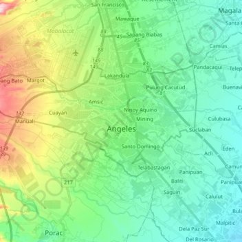
Name: Topografische Karte Angeles, Höhe, Relief.
Ort: Angeles, Pampanga, Central Luzon, Philippines (15.10983 120.47809 15.17927 120.63715)
Durchschnittliche Höhe: 98 m
Minimale Höhe: 21 m
Maximale Höhe: 309 m
Sapangbato is the largest barangay in Angeles in terms of territory, with a total land area of 104,694 sq. meters and a population of 11,262. Located northwest of Angeles near Clark Freeport Zone, it is identified as the barangay in Angeles with the highest elevation of 750 feet above sea level. It is home to Fort Stotsenburg, also known as the Parade Grounds of Clark. apl.de.ap, member of the hip hop group The Black Eyed Peas, hails from Sapangbato. The famous Puning Hot Springs of Barangay Inararo in Porac are accessed through Sitio Target in Sapangbato.
Andere topografische Karten
Klicken Sie auf eine Karte, um ihre Topografie, ihre Höhe und ihr Relief anzuzeigen.
![Topografische Karte Porac, Höhe, Relief](/pub/maps/relation/c35k/q1c8dn/icon.jpg)
Porac
Porac, Pampanga, Central Luzon, 2008, Philippines
Durchschnittliche Höhe: 170 m
![Topografische Karte Purok 1, Höhe, Relief](/pub/maps/node/s4gp/5h7hwb14/icon.jpg)
Purok 1
Philippines > Pampanga > San Juan
Purok 1, St. Jude Phase III, San Juan, Pampanga, Central Luzon, 2000, Philippines
Durchschnittliche Höhe: 7 m
![Topografische Karte Porac, Höhe, Relief](/pub/maps/node/8snh/7zqjvz4/icon.jpg)
Porac
Philippines > Pampanga > Porac
Porac, Pampanga, Central Luzon, 2008, Philippines
Durchschnittliche Höhe: 91 m
![Topografische Karte Santa Rita, Höhe, Relief](/pub/maps/node/7z3l/w11flzs/icon.jpg)
Santa Rita
Philippines > Pampanga > Santa Rita
Santa Rita, Pampanga, Central Luzon, 2002, Philippines
Durchschnittliche Höhe: 13 m
![Topografische Karte Arayat, Höhe, Relief](/pub/maps/node/m514/dj5gsgp/icon.jpg)
Arayat
Philippines > Pampanga > Arayat
Arayat, Pampanga, Central Luzon, 2012, Philippines
Durchschnittliche Höhe: 40 m
![Topografische Karte San Fernando, Höhe, Relief](/pub/maps/node/sdz4/hbzc1fgp/icon.jpg)
San Fernando
Philippines > Pampanga > San Fernando
San Fernando, Pampanga, Central Luzon, 85004, Philippines
Durchschnittliche Höhe: 24 m
![Topografische Karte Apalit, Höhe, Relief](/pub/maps/node/d7mt/lb5pjdn/icon.jpg)
Apalit
Philippines > Pampanga > Apalit
Apalit, Pampanga, Central Luzon, 2016, Philippines
Durchschnittliche Höhe: 4 m
![Topografische Karte Santa Ana, Höhe, Relief](/pub/maps/node/wb3/p672l3q/icon.jpg)
Santa Ana
Philippines > Pampanga > Santa Ana
Santa Ana, Pampanga, Central Luzon, 2022, Philippines
Durchschnittliche Höhe: 7 m
![Topografische Karte Lanang, Höhe, Relief](/pub/maps/node/b4zs/b7ktmm2/icon.jpg)
Lanang
Philippines > Pampanga > Lanang
Lanang, Candaba, Pampanga, Central Luzon, 2013, Philippines
Durchschnittliche Höhe: 7 m
![Topografische Karte Mabalacat, Höhe, Relief](/pub/maps/node/z51/mfk9mzdn/icon.jpg)
Mabalacat
Philippines > Pampanga > Mabalacat
Mabalacat, Pampanga, Central Luzon, 2010, Philippines
Durchschnittliche Höhe: 149 m