
Topografische Karte Papillion
Interaktive Karte
Klicken Sie auf die Karte, um die Höhe anzuzeigen.
Über diese Karte
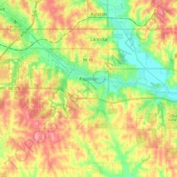
Name: Topografische Karte Papillion, Höhe, Relief.
Ort: Papillion, Sarpy County, Nebraska, 68046, United States (41.11796 -96.15821 41.17633 -95.98621)
Durchschnittliche Höhe: 338 m
Minimale Höhe: 297 m
Maximale Höhe: 381 m
Andere topografische Karten
Klicken Sie auf eine Karte, um ihre Topografie, ihre Höhe und ihr Relief anzuzeigen.
Chalco
United States > Nebraska > Sarpy County
Chalco, Sarpy County, Nebraska, 68138, United States
Durchschnittliche Höhe: 346 m
Bellevue
United States > Nebraska > Sarpy County
Bellevue, Sarpy County, Nebraska, United States
Durchschnittliche Höhe: 315 m
La Vista
United States > Nebraska > Sarpy County
La Vista, Sarpy County, Nebraska, 68128, United States
Durchschnittliche Höhe: 330 m
Fontenelle Forest
United States > Nebraska > Sarpy County > Bellevue
Fontenelle Forest, Bellevue, Sarpy County, Nebraska, 68123, United States
Durchschnittliche Höhe: 316 m
Prairie Queen Recreation Area
United States > Nebraska > Sarpy County > Papillion
Prairie Queen Recreation Area, Papillion, Sarpy County, Nebraska, United States
Durchschnittliche Höhe: 346 m
Gretna
United States > Nebraska > Sarpy County
Gretna, Sarpy County, Nebraska, 68028, United States
Durchschnittliche Höhe: 363 m
Springfield
United States > Nebraska > Sarpy County > Springfield
Springfield, Sarpy County, Nebraska, 68059, United States
Durchschnittliche Höhe: 344 m