
Topografische Karte Kartuzy
Interaktive Karte
Klicken Sie auf die Karte, um die Höhe anzuzeigen.
Über diese Karte
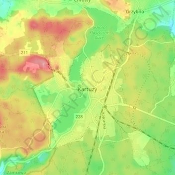
Name: Topografische Karte Kartuzy, Höhe, Relief.
Durchschnittliche Höhe: 217 m
Minimale Höhe: 171 m
Maximale Höhe: 265 m
Kartuzy is located about 32 kilometres (20 miles) west of Gdańsk and 35 km (22 miles) south-east of the town of Lębork on a plateau at an altitude of approximately 200 metres (656 feet) above sea level in the average. The plateau, which is divided by the Radaune lake, comprises the highest parts of the Baltic Sea Plate. In the west of this lake are the highest points of the headwaters of rivers Łeba, Słupia and Bukowina at an altitude of up to 271 metres (889 feet). A hill in the south of the lake is 331 metres (1,086 feet) high.
Andere topografische Karten
Klicken Sie auf eine Karte, um ihre Topografie, ihre Höhe und ihr Relief anzuzeigen.
Chmielno
Poland > Pomeranian Voivodeship > Kartuzy County
Chmielno, gmina Chmielno, Kartuzy County, Pomeranian Voivodeship, 83-333, Poland
Durchschnittliche Höhe: 180 m
Wieżyca
Poland > Pomeranian Voivodeship > Kartuzy County > Kolano
Wieżyca, Kolano, gmina Stężyca, Kartuzy County, Pomeranian Voivodeship, 83-315, Poland
Durchschnittliche Höhe: 247 m