
Topografische Karte Frisby on the Wreake
Interaktive Karte
Klicken Sie auf die Karte, um die Höhe anzuzeigen.
Über diese Karte
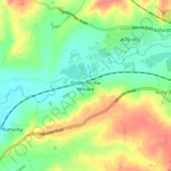
Name: Topografische Karte Frisby on the Wreake, Höhe, Relief.
Durchschnittliche Höhe: 83 m
Minimale Höhe: 58 m
Maximale Höhe: 117 m
Andere topografische Karten
Klicken Sie auf eine Karte, um ihre Topografie, ihre Höhe und ihr Relief anzuzeigen.
Sproxton
United Kingdom > England > Leicestershire > Borough of Melton > Sproxton
Sproxton, Borough of Melton, Leicestershire, England, United Kingdom
Durchschnittliche Höhe: 137 m
Eye Kettleby
United Kingdom > England > Leicestershire > Borough of Melton > Melton Mowbray
Eye Kettleby, Melton Mowbray, Borough of Melton, Leicestershire, England, LE14 2TD, United Kingdom
Durchschnittliche Höhe: 95 m
Somerby
United Kingdom > England > Leicestershire > Borough of Melton
Somerby, Borough of Melton, Leicestershire, England, LE14 2QA, United Kingdom
Durchschnittliche Höhe: 169 m
Long Clawson
United Kingdom > England > Leicestershire > Borough of Melton
Long Clawson, Borough of Melton, Leicestershire, England, LE14 4NA, United Kingdom
Durchschnittliche Höhe: 78 m
Garthorpe
United Kingdom > England > Leicestershire > Borough of Melton
Garthorpe, Borough of Melton, Leicestershire, England, LE14 2SJ, United Kingdom
Durchschnittliche Höhe: 115 m
Buckminster
United Kingdom > England > Leicestershire > Borough of Melton
Buckminster, Borough of Melton, Leicestershire, England, NG33 5SB, United Kingdom
Durchschnittliche Höhe: 138 m