
Topografische Karte Centerville
Interaktive Karte
Klicken Sie auf die Karte, um die Höhe anzuzeigen.
Über diese Karte
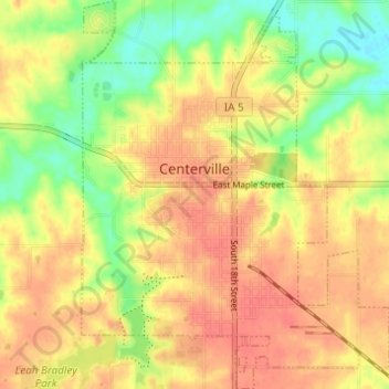
Name: Topografische Karte Centerville, Höhe, Relief.
Ort: Centerville, Appanoose County, Iowa, 52544, United States (40.70811 -92.89205 40.75446 -92.84358)
Durchschnittliche Höhe: 293 m
Minimale Höhe: 261 m
Maximale Höhe: 315 m
Andere topografische Karten
Klicken Sie auf eine Karte, um ihre Topografie, ihre Höhe und ihr Relief anzuzeigen.
Numa
United States > Iowa > Appanoose County
Numa, Appanoose County, Iowa, United States
Durchschnittliche Höhe: 303 m
Moravia
United States > Iowa > Appanoose County > Moravia > Moravia
Moravia, Appanoose County, Iowa, 52571, United States
Durchschnittliche Höhe: 298 m
Moulton
United States > Iowa > Appanoose County
Moulton, Appanoose County, Iowa, United States
Durchschnittliche Höhe: 297 m