
Topografische Karte Scottsdale
Interaktive Karte
Klicken Sie auf die Karte, um die Höhe anzuzeigen.
Über diese Karte
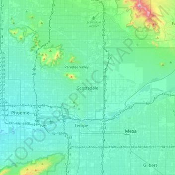
Name: Topografische Karte Scottsdale, Höhe, Relief.
Ort: Scottsdale, Maricopa County, Arizona, 85251, United States (33.33422 -112.08602 33.65422 -111.76602)
Durchschnittliche Höhe: 414 m
Minimale Höhe: 306 m
Maximale Höhe: 1.193 m
The city is in the Salt River Valley, or the "Valley of the Sun," in the northern reaches of the Sonoran Desert. Scottsdale, 31 mi (50 km) long and 11.4 mi (18.3 km) wide at its widest point, shares boundaries with many other municipalities and entities. On the west, Scottsdale is bordered by Phoenix, Paradise Valley, and unincorporated Maricopa County land. Carefree is along the eastern boundary, as well as sharing Scottsdale's northern boundary with the Tonto National Forest. To the south Scottsdale is bordered by Tempe. The southern boundary is also occupied by the Salt River Pima-Maricopa Indian Community, which extends along the eastern boundary, which also borders Fountain Hills, the McDowell Mountain Regional Park and more unincorporated Maricopa County land. The highest point is Butte Peak at an elevation of 4,890 ft.
Andere topografische Karten
Klicken Sie auf eine Karte, um ihre Topografie, ihre Höhe und ihr Relief anzuzeigen.
Gateway Trailhead
United States > Arizona > Maricopa County > Scottsdale
Gateway Trailhead, Scottsdale, Maricopa County, Arizona, 85255, United States
Durchschnittliche Höhe: 530 m