
Topografische Karte Oberhof
Interaktive Karte
Klicken Sie auf die Karte, um die Höhe anzuzeigen.
Über diese Karte
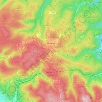
Name: Topografische Karte Oberhof, Höhe, Relief.
Durchschnittliche Höhe: 749 m
Minimale Höhe: 488 m
Maximale Höhe: 976 m
Oberhof is located in the Thuringian Forest, a low mountain range, at an altitude of about 815 meters. The town is located on a plateau, which is why there are no great differences in altitude in the built-up area. About four kilometers to the southeast are the two highest mountains in Thuringia, the 983-meter-high Großer Beerberg and the 978-meter-high Schneekopf. Southwest of Oberhof there are also two Rennsteig passes: the pass at the Grenzadler (former state border between the Duchy of Saxe-Coburg and Gotha and Prussia) and the pass at the Rondell monument. Several rivers also rise near Oberhof, the Gera in the east, the Ohra in the north, the Hasel in the south and the Schönau in the west. The surroundings of Oberhof are completely forested, the most common tree species is spruce.
Andere topografische Karten
Klicken Sie auf eine Karte, um ihre Topografie, ihre Höhe und ihr Relief anzuzeigen.
Rotterode
Germany > Thuringia > Landkreis Schmalkalden-Meiningen > Steinbach-Hallenberg
Rotterode, Steinbach-Hallenberg, Landkreis Schmalkalden-Meiningen, Thuringia, 98587, Germany
Durchschnittliche Höhe: 570 m
Roßdorf
Germany > Thuringia > Landkreis Schmalkalden-Meiningen
Roßdorf, Breitungen/Werra, Landkreis Schmalkalden-Meiningen, Thuringia, Germany
Durchschnittliche Höhe: 436 m
Meiningen
Germany > Thuringia > Landkreis Schmalkalden-Meiningen > Meiningen
Meiningen, Kernstadt Meiningen, Meiningen, Landkreis Schmalkalden-Meiningen, Thuringia, 98617, Germany
Durchschnittliche Höhe: 394 m
Breitungen/Werra
Germany > Thuringia > Landkreis Schmalkalden-Meiningen
Breitungen/Werra, Landkreis Schmalkalden-Meiningen, Thuringia, Germany
Durchschnittliche Höhe: 345 m
Schmalkalden
Germany > Thuringia > Landkreis Schmalkalden-Meiningen
Schmalkalden, Landkreis Schmalkalden-Meiningen, Thuringia, 98574, Germany
Durchschnittliche Höhe: 452 m
Zella-Mehlis
Germany > Thuringia > Landkreis Schmalkalden-Meiningen
Zella-Mehlis, Landkreis Schmalkalden-Meiningen, Thuringia, 98544, Germany
Durchschnittliche Höhe: 628 m