
Spenden
Rüste dich für dein nächstes Abenteuer:
Als Amazon-Partner verdient diese Website an qualifizierten Käufen, ohne zusätzliche Kosten für Sie.
Topografische Karte Paramos
Klicken Sie auf die Karte, um die Höhe anzuzeigen.
Spenden
Rüste dich für dein nächstes Abenteuer:
Als Amazon-Partner verdient diese Website an qualifizierten Käufen, ohne zusätzliche Kosten für Sie.
Paramos
Posição: 40º 58′ 24″ N , 008º 38′ 43″ W ( ARP – eixo da pista, 100m da soleira da pista 17 ) Declinação Magnética: 04º 01′ (2006) Distância/Direcção à Localidade: 3 km / 1.6 nm S Altitude Máxima: 3m / 10′
Spenden
Rüste dich für dein nächstes Abenteuer:
Als Amazon-Partner verdient diese Website an qualifizierten Käufen, ohne zusätzliche Kosten für Sie.
Über diese Karte
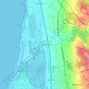
Name: Topografische Karte Paramos, Höhe, Relief.
Ort: Paramos, Espinho, Aveiro, Portugal (40.96478 -8.65312 40.98473 -8.61070)
Durchschnittliche Höhe: 20 m
Minimale Höhe: -2 m
Maximale Höhe: 90 m
Spenden
Rüste dich für dein nächstes Abenteuer:
Als Amazon-Partner verdient diese Website an qualifizierten Käufen, ohne zusätzliche Kosten für Sie.
Andere topografische Karten
Klicken Sie auf eine Karte, um ihre Topografie, ihre Höhe und ihr Relief anzuzeigen.
Spenden
Rüste dich für dein nächstes Abenteuer:
Als Amazon-Partner verdient diese Website an qualifizierten Käufen, ohne zusätzliche Kosten für Sie.