
Topografische Karte Strathyre
Interaktive Karte
Klicken Sie auf die Karte, um die Höhe anzuzeigen.
Über diese Karte
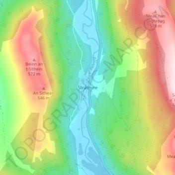
Name: Topografische Karte Strathyre, Höhe, Relief.
Ort: Strathyre, Stirling, Scotland, FK18 8NL, United Kingdom (56.30450 -4.34930 56.34450 -4.30930)
Durchschnittliche Höhe: 326 m
Minimale Höhe: 119 m
Maximale Höhe: 638 m
Andere topografische Karten
Klicken Sie auf eine Karte, um ihre Topografie, ihre Höhe und ihr Relief anzuzeigen.
Kenknock
United Kingdom > Scotland > Stirling
Kenknock, Stirling, Scotland, FK21 8UB, United Kingdom
Durchschnittliche Höhe: 434 m
Loch Venachar
United Kingdom > Scotland > Stirling
Loch Venachar, Stirling, Scotland, United Kingdom
Durchschnittliche Höhe: 219 m
Falls of Leny
United Kingdom > Scotland > Stirling
Falls of Leny, Stirling, Scotland, FK17 8HQ, United Kingdom
Durchschnittliche Höhe: 214 m
Ben A'an
United Kingdom > Scotland > Stirling
Ben A'an, Stirling, Scotland, FK17 8HZ, United Kingdom
Durchschnittliche Höhe: 283 m
Throsk
United Kingdom > Scotland > Stirling
Throsk, Stirling, Scotland, FK7 7NA, United Kingdom
Durchschnittliche Höhe: 12 m
Duchray Water
United Kingdom > Scotland > Stirling
Duchray Water, Stirling, Scotland, United Kingdom
Durchschnittliche Höhe: 212 m
Loch Ardinning
United Kingdom > Scotland > Stirling > Mugdock
Loch Ardinning, Mugdock, Stirling, Scotland, United Kingdom
Durchschnittliche Höhe: 136 m
Dunblane
United Kingdom > Scotland > Stirling
Dunblane, Stirling, Scotland, FK15 0EJ, United Kingdom
Durchschnittliche Höhe: 117 m
Ben Ledi
United Kingdom > Scotland > Stirling
Ben Ledi, Stirling, Scotland, FK17 8HR, United Kingdom
Durchschnittliche Höhe: 544 m
Deanston
United Kingdom > Scotland > Stirling
Deanston, Stirling, Scotland, FK16 6AJ, United Kingdom
Durchschnittliche Höhe: 56 m
Loch Lomond
United Kingdom > Scotland > Stirling > Balmaha
Loch Lomond, Balmaha, Stirling, Scotland, G83 8QZ, United Kingdom
Durchschnittliche Höhe: 240 m
Achray Water
United Kingdom > Scotland > Stirling
Achray Water, Stirling, Scotland, FK17 8HZ, United Kingdom
Durchschnittliche Höhe: 167 m
Kinlochard
United Kingdom > Scotland > Stirling
Kinlochard, Stirling, Scotland, FK8 3TL, United Kingdom
Durchschnittliche Höhe: 177 m
Milton
United Kingdom > Scotland > Stirling
Milton, Stirling, Scotland, FK8 3TF, United Kingdom
Durchschnittliche Höhe: 156 m
Loch Lomond and The Trossachs National Park
United Kingdom > Scotland > Stirling
Loch Lomond and The Trossachs National Park, Stirling, Scotland, United Kingdom
Durchschnittliche Höhe: 291 m
Kingshouse
United Kingdom > Scotland > Stirling
Kingshouse, Stirling, Scotland, FK19 8NZ, United Kingdom
Durchschnittliche Höhe: 319 m
Aberfoyle
United Kingdom > Scotland > Stirling
Aberfoyle, Stirling, Scotland, FK8 3UH, United Kingdom
Durchschnittliche Höhe: 129 m
Glen Ogle
United Kingdom > Scotland > Stirling > Lochearnhead
Glen Ogle, Lochearnhead, Stirling, Scotland, FK19 8PR, United Kingdom
Durchschnittliche Höhe: 463 m
Campsie Fells
United Kingdom > Scotland > Stirling
Campsie Fells, Stirling, Scotland, United Kingdom
Durchschnittliche Höhe: 156 m
Ben Lomond
United Kingdom > Scotland > Stirling
Ben Lomond, Stirling, Scotland, G63 0AR, United Kingdom
Durchschnittliche Höhe: 575 m
Lake of Menteith
United Kingdom > Scotland > Stirling
Lake of Menteith, Stirling, Scotland, United Kingdom
Durchschnittliche Höhe: 31 m
Beinn Chabhair
United Kingdom > Scotland > Stirling
Beinn Chabhair, Stirling, Scotland, FK8 3UB, United Kingdom
Durchschnittliche Höhe: 599 m
Doune
United Kingdom > Scotland > Stirling
Doune, Stirling, Scotland, United Kingdom
Durchschnittliche Höhe: 48 m
Bridge of Allan
United Kingdom > Scotland > Stirling
Bridge of Allan, Stirling, Scotland, FK9 4HW, United Kingdom
Durchschnittliche Höhe: 80 m
Carbeth
United Kingdom > Scotland > Stirling > Carbeth
Carbeth, Stirling, Scotland, G63 9AF, United Kingdom
Durchschnittliche Höhe: 159 m
Kirkton
United Kingdom > Scotland > Stirling > Kirkton
Kirkton, Stirling, Scotland, FK20 8RU, United Kingdom
Durchschnittliche Höhe: 339 m
Killin
United Kingdom > Scotland > Stirling
Killin, Stirling, Scotland, United Kingdom
Durchschnittliche Höhe: 174 m
Loch Chon
United Kingdom > Scotland > Stirling
Loch Chon, Stirling, Scotland, United Kingdom
Durchschnittliche Höhe: 242 m
Loch Earn
United Kingdom > Scotland > Stirling > Lochearnhead
Loch Earn, Lochearnhead, Stirling, Scotland, United Kingdom
Durchschnittliche Höhe: 393 m
Croftamie
United Kingdom > Scotland > Stirling
Croftamie, Stirling, Scotland, G63 0EP, United Kingdom
Durchschnittliche Höhe: 48 m
Loch Ard
United Kingdom > Scotland > Stirling
Loch Ard, Stirling, Scotland, United Kingdom
Durchschnittliche Höhe: 154 m
Inversnaid
United Kingdom > Scotland > Stirling
Inversnaid, Stirling, Scotland, FK8 3TU, United Kingdom
Durchschnittliche Höhe: 163 m
Loch Doine
United Kingdom > Scotland > Stirling
Loch Doine, Stirling, Scotland, United Kingdom
Durchschnittliche Höhe: 301 m
Carron Valley Reservoir
United Kingdom > Scotland > Stirling > Stirling
Carron Valley Reservoir, Stirling, Scotland, United Kingdom
Durchschnittliche Höhe: 280 m
Crianlarich
United Kingdom > Scotland > Stirling
Crianlarich, Stirling, Scotland, FK20 8QN, United Kingdom
Durchschnittliche Höhe: 289 m
Balfron
United Kingdom > Scotland > Stirling
Balfron, Stirling, Scotland, G63 0TR, United Kingdom
Durchschnittliche Höhe: 98 m
Stronachlachar
United Kingdom > Scotland > Stirling > Stronachlachar
Stronachlachar, Stirling, Scotland, FK8 3TY, United Kingdom
Durchschnittliche Höhe: 226 m
Pass Of Leny
United Kingdom > Scotland > Stirling
Pass Of Leny, Stirling, Scotland, FK17 8HD, United Kingdom
Durchschnittliche Höhe: 188 m
Fintry
United Kingdom > Scotland > Stirling
Fintry, Stirling, Scotland, G63 0XN, United Kingdom
Durchschnittliche Höhe: 230 m
Inverlochlarig
United Kingdom > Scotland > Stirling > Inverlochlarig
Inverlochlarig, Stirling, Scotland, FK19 8PH, United Kingdom
Durchschnittliche Höhe: 379 m
Tyndrum
United Kingdom > Scotland > Stirling
Tyndrum, Stirling, Scotland, FK20 8RZ, United Kingdom
Durchschnittliche Höhe: 358 m
Lochearnhead
United Kingdom > Scotland > Stirling > Lochearnhead
Lochearnhead, Stirling, Scotland, FK19 8PR, United Kingdom
Durchschnittliche Höhe: 274 m
Mugdock Country Park
United Kingdom > Scotland > Stirling > Strathblane
Mugdock Country Park, Strathblane, Stirling, Scotland, G62 8EL, United Kingdom
Durchschnittliche Höhe: 124 m
Doune
United Kingdom > Scotland > Stirling
Doune, Stirling, Scotland, FK16 6BE, United Kingdom
Durchschnittliche Höhe: 56 m
Killearn
United Kingdom > Scotland > Stirling
Killearn, Stirling, Scotland, G63 9NH, United Kingdom
Durchschnittliche Höhe: 82 m
Balmaha
United Kingdom > Scotland > Stirling
Balmaha, Stirling, Scotland, G63 0JQ, United Kingdom
Durchschnittliche Höhe: 50 m
Plean
United Kingdom > Scotland > Stirling > Plean
Plean, Stirling, Scotland, FK7 8DA, United Kingdom
Durchschnittliche Höhe: 51 m
Balquhidder
United Kingdom > Scotland > Stirling
Balquhidder, Stirling, Scotland, FK19 8PA, United Kingdom
Durchschnittliche Höhe: 344 m
Cambusbarron
United Kingdom > Scotland > Stirling > Cambusbarron
Cambusbarron, Stirling, Scotland, FK7 9NW, United Kingdom
Durchschnittliche Höhe: 47 m