
Topografische Karte Queen Valley
Interaktive Karte
Klicken Sie auf die Karte, um die Höhe anzuzeigen.
Über diese Karte
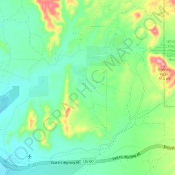
Name: Topografische Karte Queen Valley, Höhe, Relief.
Ort: Queen Valley, Pinal County, Arizona, United States (33.25274 -111.34105 33.31838 -111.26798)
Durchschnittliche Höhe: 633 m
Minimale Höhe: 568 m
Maximale Höhe: 804 m
Queen Valley is located at 33°17′42″N 111°17′52″W / 33.29500°N 111.29778°W / 33.29500; -111.29778. at an elevation of 2000 feet along the south side of the west flowing Queen Creek. The Tonto National Forest boundary and Comet Peak (2681 ft.) lie 1.5 miles to the east. The dam for the Whitlow Ranch Flood Control Basin is one mile to the east.
Andere topografische Karten
Klicken Sie auf eine Karte, um ihre Topografie, ihre Höhe und ihr Relief anzuzeigen.
San Tan Valley
United States > Arizona > Pinal County
San Tan Valley, Pinal County, Arizona, 85243, United States
Durchschnittliche Höhe: 463 m
Casa Grande
United States > Arizona > Pinal County
Casa Grande, Pinal County, Arizona, United States
Durchschnittliche Höhe: 439 m
Tiger
United States > Arizona > Pinal County
Tiger, Pinal County, Arizona, 85618, United States
Durchschnittliche Höhe: 928 m