
Topografische Karte Oak Park
Interaktive Karte
Klicken Sie auf die Karte, um die Höhe anzuzeigen.
Über diese Karte
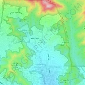
Name: Topografische Karte Oak Park, Höhe, Relief.
Durchschnittliche Höhe: 378 m
Minimale Höhe: 281 m
Maximale Höhe: 638 m
Andere topografische Karten
Klicken Sie auf eine Karte, um ihre Topografie, ihre Höhe und ihr Relief anzuzeigen.
Simi Valley
United States > California > Ventura County
Simi Valley, Ventura County, CAL Fire Contract Counties, California, United States
Durchschnittliche Höhe: 405 m
Santa Susana
United States > California > Ventura County > Simi Valley
Santa Susana, Simi Valley, Ventura County, California, 93064, United States
Durchschnittliche Höhe: 324 m
Ventura
United States > California > Ventura County
Ventura, Ventura County, CAL Fire Contract Counties, California, United States
Durchschnittliche Höhe: 134 m
Thousand Oaks
United States > California > Ventura County
Thousand Oaks, Ventura County, CAL Fire Southern Region, California, United States
Durchschnittliche Höhe: 333 m
Camarillo
United States > California > Ventura County
Camarillo, Ventura County, California, United States
Durchschnittliche Höhe: 90 m
Channel Islands National Park
United States > California > Ventura County
Channel Islands National Park, Ventura County, California, United States
Durchschnittliche Höhe: 6 m