
Topografische Karte Owls Head
Interaktive Karte
Klicken Sie auf die Karte, um die Höhe anzuzeigen.
Über diese Karte
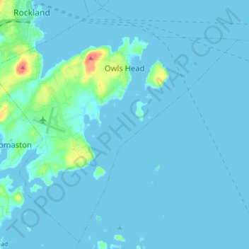
Name: Topografische Karte Owls Head, Höhe, Relief.
Ort: Owls Head, Knox County, Maine, 04854, United States (44.01220 -69.13335 44.10654 -68.99374)
Durchschnittliche Höhe: 4 m
Minimale Höhe: -2 m
Maximale Höhe: 57 m
Andere topografische Karten
Klicken Sie auf eine Karte, um ihre Topografie, ihre Höhe und ihr Relief anzuzeigen.
North Haven Island
United States > Maine > Knox County > North Haven
North Haven Island, North Haven, Knox County, Maine, 04853, United States
Durchschnittliche Höhe: 6 m
Penobscot Bay
United States > Maine > Knox County > North Haven
Penobscot Bay, North Haven, Knox County, Maine, United States
Durchschnittliche Höhe: 0 m
Glen Cove
United States > Maine > Knox County > Rockport
Glen Cove, Rockport, Knox County, Maine, 04841, United States
Durchschnittliche Höhe: 30 m
Rockland
United States > Maine > Knox County
Rockland, Knox County, Maine, 04841, United States
Durchschnittliche Höhe: 37 m
Vinalhaven
United States > Maine > Knox County
Vinalhaven, Knox County, Maine, 04863, United States
Durchschnittliche Höhe: 2 m