
Spenden
Rüste dich für dein nächstes Abenteuer:
Als Amazon-Partner verdient diese Website an qualifizierten Käufen, ohne zusätzliche Kosten für Sie.
Topografische Karte Pahalgam
Klicken Sie auf die Karte, um die Höhe anzuzeigen.
Spenden
Rüste dich für dein nächstes Abenteuer:
Als Amazon-Partner verdient diese Website an qualifizierten Käufen, ohne zusätzliche Kosten für Sie.
Pahalgam
Pahalgam (Hindustani pronunciation: [pɛhɛlɡaːm]), known as Pahalgom (Kashmiri pronunciation: [pəhəlʲɡoːm]; lit. 'village of shepherds' in Kashmiri) is a town and a notified area committee, near Anantnag city in the Anantnag district of the Indian-administered union territory of Jammu and Kashmir. It is a popular tourist destination and hill station. Its lush green meadows and pristine waters attract thousands of tourists from all over the world each year. It is located 45 kilometres (28 mi) from Anantnag on the banks of Lidder River at an altitude of 7,200 feet (2,200 m). Pahalgam is the headquarters of one of the eleven tehsils of Anantnag district.
Spenden
Rüste dich für dein nächstes Abenteuer:
Als Amazon-Partner verdient diese Website an qualifizierten Käufen, ohne zusätzliche Kosten für Sie.
Über diese Karte
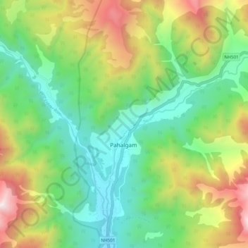
Name: Topografische Karte Pahalgam, Höhe, Relief.
Ort: Pahalgam, Anantnag district, Jammu and Kashmir, 192126, India (33.99220 75.28265 34.07220 75.36265)
Durchschnittliche Höhe: 2.700 m
Minimale Höhe: 2.082 m
Maximale Höhe: 3.909 m
Spenden
Rüste dich für dein nächstes Abenteuer:
Als Amazon-Partner verdient diese Website an qualifizierten Käufen, ohne zusätzliche Kosten für Sie.
Andere topografische Karten
Klicken Sie auf eine Karte, um ihre Topografie, ihre Höhe und ihr Relief anzuzeigen.