
Topografische Karte Roswell
Interaktive Karte
Klicken Sie auf die Karte, um die Höhe anzuzeigen.
Über diese Karte
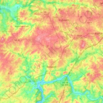
Name: Topografische Karte Roswell, Höhe, Relief.
Ort: Roswell, Fulton County, Georgia, United States (33.97174 -84.41913 34.11824 -84.26159)
Durchschnittliche Höhe: 316 m
Minimale Höhe: 257 m
Maximale Höhe: 369 m
Andere topografische Karten
Klicken Sie auf eine Karte, um ihre Topografie, ihre Höhe und ihr Relief anzuzeigen.
Johns Creek
United States > Georgia > Fulton County > Johns Creek
Johns Creek, Fulton County, Georgia, 30097, United States
Durchschnittliche Höhe: 305 m
Atlanta
United States > Georgia > Fulton County
Atlanta, Fulton County, Georgia, 30303, United States
Durchschnittliche Höhe: 285 m
Milton
United States > Georgia > Fulton County
Milton, Fulton County, Georgia, 30004, United States
Durchschnittliche Höhe: 330 m
Fort McPherson
United States > Georgia > Fulton County > Atlanta
Fort McPherson, Atlanta, Fulton County, Georgia, 30330, United States
Durchschnittliche Höhe: 309 m
Fairburn
United States > Georgia > Fulton County > Fairburn
Fairburn, Fulton County, Georgia, 30213, United States
Durchschnittliche Höhe: 293 m
Mountain Park
United States > Georgia > Fulton County > Mountain Park
Mountain Park, Fulton County, Georgia, United States
Durchschnittliche Höhe: 312 m
Atlanta
United States > Georgia > Fulton County
Atlanta, Fulton County, Georgia, United States
Durchschnittliche Höhe: 284 m