
Topografische Karte Moroto
Interaktive Karte
Klicken Sie auf die Karte, um die Höhe anzuzeigen.
Moroto
Moroto is located approximately 528 kilometres (328 mi), by road, northeast of Kampala, the capital and largest city of Uganda. The geographical coordinates of Moroto Town are 2°31'48.0"N, 34°40'12.0"E (Latitude:2.5300; Longitude:34.6700). Moroto sits at an average elevation of 1,370 metres (4,490 ft) above mean sea level.
Über diese Karte
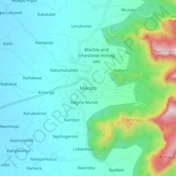
Name: Topografische Karte Moroto, Höhe, Relief.
Ort: Moroto, Northern Region, Uganda (2.48862 34.61873 2.56862 34.69873)
Durchschnittliche Höhe: 1.429 m
Minimale Höhe: 1.274 m
Maximale Höhe: 2.103 m