
Topografische Karte Seixal
Interaktive Karte
Klicken Sie auf die Karte, um die Höhe anzuzeigen.
Über diese Karte
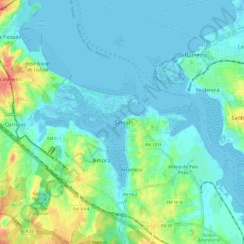
Name: Topografische Karte Seixal, Höhe, Relief.
Durchschnittliche Höhe: 43 m
Minimale Höhe: -3 m
Maximale Höhe: 462 m
Although the municipal population continued to grow with development, after the 1970s there was a boom in the population, due to improvements in accessibility and mobility, principally due to public transport, its location to Lisbon and installation of economic activities within the territory. This growth transformed, in a short time, from a territory predominantly rural into an urban municipality, consisting of agglomerations of large dimensions focusing on various establishments and social centres. This growth resulted in the 1993 elevation of Seixal and Amora into cities, and the establishment of Corroios into the status of town.
Andere topografische Karten
Klicken Sie auf eine Karte, um ihre Topografie, ihre Höhe und ihr Relief anzuzeigen.
Alto do Moinho
Portugal > Setúbal > Seixal > Corroios
Alto do Moinho, Corroios, Seixal, Setúbal, 2855-719, Portugal
Durchschnittliche Höhe: 36 m