
Topografische Karte Balikpapan
Interaktive Karte
Klicken Sie auf die Karte, um die Höhe anzuzeigen.
Balikpapan
Topography of Balikpapan is generally hilly (85%), with only small areas of flat land (15%), mostly along the coast and surrounding the hilly areas. The hills are less than 100 meters (330 feet) higher than the adjacent valleys. The altitude of Balikpapan ranges from 0 to 80 meters (260 feet) above sea level. The city proper itself is located on eastern side of Bay of Balikpapan.
Über diese Karte
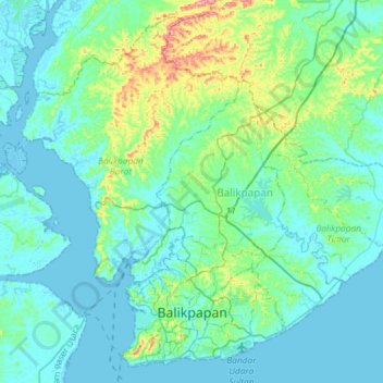
Name: Topografische Karte Balikpapan, Höhe, Relief.
Ort: Balikpapan, East Kalimantan, Kalimantan, Indonesia (-1.28233 116.72880 -1.01330 117.02267)
Durchschnittliche Höhe: 21 m
Minimale Höhe: -5 m
Maximale Höhe: 129 m
Andere topografische Karten
Klicken Sie auf eine Karte, um ihre Topografie, ihre Höhe und ihr Relief anzuzeigen.