
Topografische Karte Kebai Khelma
Interaktive Karte
Klicken Sie auf die Karte, um die Höhe anzuzeigen.
Über diese Karte
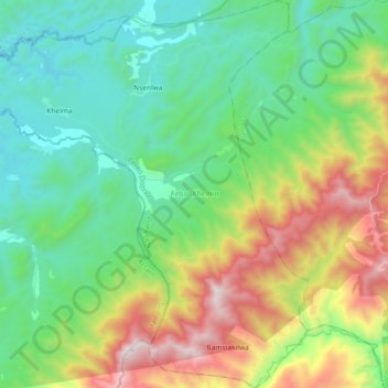
Name: Topografische Karte Kebai Khelma, Höhe, Relief.
Ort: Kebai Khelma, Peren District, Nagaland, India (25.34131 93.38432 25.50697 93.53914)
Durchschnittliche Höhe: 800 m
Minimale Höhe: 336 m
Maximale Höhe: 1.845 m
Andere topografische Karten
Klicken Sie auf eine Karte, um ihre Topografie, ihre Höhe und ihr Relief anzuzeigen.
Chessore Village
Chessore Village, Chessore, Tuensang, Nagaland, India
Durchschnittliche Höhe: 1.325 m
Mokokchung
India > Nagaland > ONGPANGKONG (N)
Mokokchung, ONGPANGKONG (N), Mokokchung District, Nagaland, 798601, India
Durchschnittliche Höhe: 1.027 m
Kohima
India > Nagaland > Kohima Sadar
Kohima, Kohima Sadar, Kohima District, Nagaland, 797001, India
Durchschnittliche Höhe: 1.425 m