
Topografische Karte Sky Valley
Interaktive Karte
Klicken Sie auf die Karte, um die Höhe anzuzeigen.
Über diese Karte
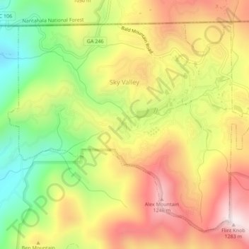
Name: Topografische Karte Sky Valley, Höhe, Relief.
Ort: Sky Valley, Rabun County, Georgia, 30537, United States (34.96659 -83.35311 34.99589 -83.31062)
Durchschnittliche Höhe: 973 m
Minimale Höhe: 652 m
Maximale Höhe: 1.275 m
According to the United States Census Bureau, the city has a total area of 3.0 square miles (7.8 km2), all land. The elevation of the valley floor is approximately 3100 feet above sea level, while areas within the city limits on the slopes of Rabun Bald exceed 4200 feet. Sky Valley is Georgia's highest incorporated city and one of the highest municipalities in the eastern United States.
Andere topografische Karten
Klicken Sie auf eine Karte, um ihre Topografie, ihre Höhe und ihr Relief anzuzeigen.
Dillard
United States > Georgia > Rabun County
Dillard, Rabun County, Georgia, United States
Durchschnittliche Höhe: 691 m
Tiger
United States > Georgia > Rabun County
Tiger, Rabun County, Georgia, United States
Durchschnittliche Höhe: 608 m
Clayton
United States > Georgia > Rabun County > Clayton
Clayton, Rabun County, Georgia, 30525, United States
Durchschnittliche Höhe: 634 m
Black Rock Mountain State Park
United States > Georgia > Rabun County
Black Rock Mountain State Park, Rabun County, Georgia, 30525, United States
Durchschnittliche Höhe: 869 m