
Topografische Karte Camden
Interaktive Karte
Klicken Sie auf die Karte, um die Höhe anzuzeigen.
Über diese Karte
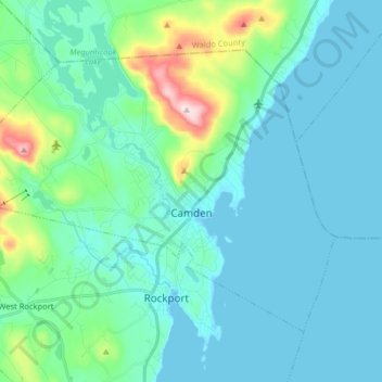
Name: Topografische Karte Camden, Höhe, Relief.
Ort: Camden, Knox County, Maine, 04843, United States (44.17420 -69.16544 44.25946 -69.00469)
Durchschnittliche Höhe: 63 m
Minimale Höhe: -2 m
Maximale Höhe: 410 m
According to the U.S. Census Bureau, the town has a total area of 26.65 square miles (69.02 km2), of which, 18.24 square miles (47.24 km2) of it is land and 8.41 square miles (21.78 km2) is water. Drained by the Megunticook River, Camden is located beside Penobscot Bay and the Gulf of Maine, part of the Atlantic Ocean. Principal bodies of water include: Megunticook Lake, Hosmer Pond (54 acres), Impoundment (Seabright Pond) (74 acres) and Lily Pond (32 acres). Mount Megunticook has an elevation of 1385 feet (419 m).
Andere topografische Karten
Klicken Sie auf eine Karte, um ihre Topografie, ihre Höhe und ihr Relief anzuzeigen.
Warren
United States > Maine > Knox County
Warren, Knox County, Maine, 04864, United States
Durchschnittliche Höhe: 47 m
Matinicus Island
United States > Maine > Knox County > Matinicus Isle Plantation
Matinicus Island, Matinicus Isle Plantation, Knox County, Maine, United States
Durchschnittliche Höhe: 5 m
Rockport
United States > Maine > Knox County
Rockport, Knox County, Maine, United States
Durchschnittliche Höhe: 41 m
South Thomaston
United States > Maine > Knox County > South Thomaston
South Thomaston, Knox County, Maine, 04858, United States
Durchschnittliche Höhe: 10 m
Saint George
United States > Maine > Knox County
Saint George, Knox County, Maine, United States
Durchschnittliche Höhe: 3 m
Hope
United States > Maine > Knox County
Hope, Knox County, Maine, 04847, United States
Durchschnittliche Höhe: 119 m
Appleton
United States > Maine > Knox County
Appleton, Knox County, Maine, United States
Durchschnittliche Höhe: 105 m
Friendship
United States > Maine > Knox County
Friendship, Knox County, Maine, 04547, United States
Durchschnittliche Höhe: 10 m
Union
United States > Maine > Knox County
Union, Knox County, Maine, 04862, United States
Durchschnittliche Höhe: 89 m
Matinicus Isle Plantation
United States > Maine > Knox County
Matinicus Isle Plantation, Knox County, Maine, 04851, United States
Durchschnittliche Höhe: 0 m
Owls Head
United States > Maine > Knox County
Owls Head, Knox County, Maine, 04854, United States
Durchschnittliche Höhe: 4 m
Vinalhaven
United States > Maine > Knox County
Vinalhaven, Knox County, Maine, 04863, United States
Durchschnittliche Höhe: 2 m
Penobscot Bay
United States > Maine > Knox County > North Haven
Penobscot Bay, North Haven, Knox County, Maine, United States
Durchschnittliche Höhe: 0 m
Rockland
United States > Maine > Knox County
Rockland, Knox County, Maine, 04841, United States
Durchschnittliche Höhe: 37 m