
Spenden
Rüste dich für dein nächstes Abenteuer:
Als Amazon-Partner verdient diese Website an qualifizierten Käufen, ohne zusätzliche Kosten für Sie.
Topografische Karte Slip End
Klicken Sie auf die Karte, um die Höhe anzuzeigen.
Spenden
Rüste dich für dein nächstes Abenteuer:
Als Amazon-Partner verdient diese Website an qualifizierten Käufen, ohne zusätzliche Kosten für Sie.
Über diese Karte
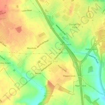
Name: Topografische Karte Slip End, Höhe, Relief.
Ort: Slip End, Central Bedfordshire, England, United Kingdom (51.84670 -0.45217 51.86706 -0.42166)
Durchschnittliche Höhe: 160 m
Minimale Höhe: 131 m
Maximale Höhe: 179 m
Spenden
Rüste dich für dein nächstes Abenteuer:
Als Amazon-Partner verdient diese Website an qualifizierten Käufen, ohne zusätzliche Kosten für Sie.
Andere topografische Karten
Klicken Sie auf eine Karte, um ihre Topografie, ihre Höhe und ihr Relief anzuzeigen.
Edgecote
United Kingdom > England > Central Bedfordshire > Caddington > Aley Green
Durchschnittliche Höhe: 168 m
Lower Caldecote
United Kingdom > England > Central Bedfordshire > Upper Caldecote
Durchschnittliche Höhe: 32 m
Spenden
Rüste dich für dein nächstes Abenteuer:
Als Amazon-Partner verdient diese Website an qualifizierten Käufen, ohne zusätzliche Kosten für Sie.
Dunstable Downs
United Kingdom > England > Central Bedfordshire > Church End
Because of its elevation, Dunstable Downs hosted a station in the shutter telegraph chain which connected the Admiralty in London to its naval ships in the port of Great Yarmouth during the years 1808 to 1814.
Durchschnittliche Höhe: 178 m
Spenden
Rüste dich für dein nächstes Abenteuer:
Als Amazon-Partner verdient diese Website an qualifizierten Käufen, ohne zusätzliche Kosten für Sie.
Blow's Downs
United Kingdom > England > Central Bedfordshire > Dunstable
Durchschnittliche Höhe: 164 m
Houghton Hall Park
United Kingdom > England > Central Bedfordshire > Houghton Regis
Durchschnittliche Höhe: 134 m
Spenden
Rüste dich für dein nächstes Abenteuer:
Als Amazon-Partner verdient diese Website an qualifizierten Käufen, ohne zusätzliche Kosten für Sie.
Spenden
Rüste dich für dein nächstes Abenteuer:
Als Amazon-Partner verdient diese Website an qualifizierten Käufen, ohne zusätzliche Kosten für Sie.
Spenden
Rüste dich für dein nächstes Abenteuer:
Als Amazon-Partner verdient diese Website an qualifizierten Käufen, ohne zusätzliche Kosten für Sie.
Spenden
Rüste dich für dein nächstes Abenteuer:
Als Amazon-Partner verdient diese Website an qualifizierten Käufen, ohne zusätzliche Kosten für Sie.
Dog Kennel Down
United Kingdom > England > Central Bedfordshire > Houghton Regis
Durchschnittliche Höhe: 138 m
Spenden
Rüste dich für dein nächstes Abenteuer:
Als Amazon-Partner verdient diese Website an qualifizierten Käufen, ohne zusätzliche Kosten für Sie.
Higham Gobion
United Kingdom > England > Central Bedfordshire > Shillington
Durchschnittliche Höhe: 60 m
How End
United Kingdom > England > Central Bedfordshire > Houghton Conquest
Durchschnittliche Höhe: 57 m
Spenden
Rüste dich für dein nächstes Abenteuer:
Als Amazon-Partner verdient diese Website an qualifizierten Käufen, ohne zusätzliche Kosten für Sie.
Spenden
Rüste dich für dein nächstes Abenteuer:
Als Amazon-Partner verdient diese Website an qualifizierten Käufen, ohne zusätzliche Kosten für Sie.
Spenden
Rüste dich für dein nächstes Abenteuer:
Als Amazon-Partner verdient diese Website an qualifizierten Käufen, ohne zusätzliche Kosten für Sie.
Totternhoe Knolls
United Kingdom > England > Central Bedfordshire > Church End > Lower End
Durchschnittliche Höhe: 105 m
Spenden
Rüste dich für dein nächstes Abenteuer:
Als Amazon-Partner verdient diese Website an qualifizierten Käufen, ohne zusätzliche Kosten für Sie.
Crawley Park
United Kingdom > England > Central Bedfordshire > Aspley Guise > Husborne Crawley
Durchschnittliche Höhe: 98 m
Spenden
Rüste dich für dein nächstes Abenteuer:
Als Amazon-Partner verdient diese Website an qualifizierten Käufen, ohne zusätzliche Kosten für Sie.