
Topografische Karte Ferreries
Interaktive Karte
Klicken Sie auf die Karte, um die Höhe anzuzeigen.
Über diese Karte
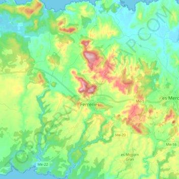
Name: Topografische Karte Ferreries, Höhe, Relief.
Ort: Ferreries, Menorca, Balearic Islands, 07750, Spain (39.92902 3.95743 40.05963 4.06378)
Durchschnittliche Höhe: 82 m
Minimale Höhe: 0 m
Maximale Höhe: 268 m
Ferreries is a municipality on the island of Menorca, in the Spanish autonomous community of the Balearic Islands. Its name is derived from the Catalan word ferrer ("blacksmith"), which in turn, comes from Latin word ferrum. At an elevation of 150 metres it is the island's highest town. Plaça Espanya