
Spenden
Rüste dich für dein nächstes Abenteuer:
Als Amazon-Partner verdient diese Website an qualifizierten Käufen, ohne zusätzliche Kosten für Sie.
Topografische Karte Playa La Chira
Klicken Sie auf die Karte, um die Höhe anzuzeigen.
Spenden
Rüste dich für dein nächstes Abenteuer:
Als Amazon-Partner verdient diese Website an qualifizierten Käufen, ohne zusätzliche Kosten für Sie.
Über diese Karte
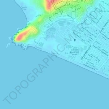
Name: Topografische Karte Playa La Chira, Höhe, Relief.
Ort: Playa La Chira, Chorrillos, Provincia de Lima, Lima, Perú (-12.21120 -77.03317 -12.20587 -77.02107)
Durchschnittliche Höhe: 7 m
Minimale Höhe: -2 m
Maximale Höhe: 104 m
Spenden
Rüste dich für dein nächstes Abenteuer:
Als Amazon-Partner verdient diese Website an qualifizierten Käufen, ohne zusätzliche Kosten für Sie.
Andere topografische Karten
Klicken Sie auf eine Karte, um ihre Topografie, ihre Höhe und ihr Relief anzuzeigen.
Morro Solar
Perú > Lima > Chorrillos
Por su elevación, los cerros que circundan el Morro Solar son actualmente utilizados para la instalación de antenas retransmisoras de los canales de televisión y de algunas radios de Lima.
Durchschnittliche Höhe: 38 m