
Topografische Karte Johannesburg
Interaktive Karte
Klicken Sie auf die Karte, um die Höhe anzuzeigen.
Über diese Karte
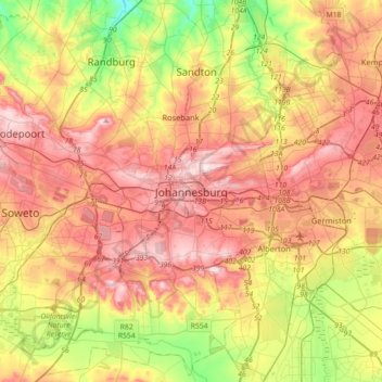
Name: Topografische Karte Johannesburg, Höhe, Relief.
Durchschnittliche Höhe: 1.615 m
Minimale Höhe: 1.410 m
Maximale Höhe: 1.809 m
Johannesburg is located in the eastern plateau area of South Africa known as the Highveld, at an elevation of 1,753 metres (5,751 ft). The former Central Business District is located on the southern side of the prominent ridge called the Witwatersrand (English: White Water's Ridge) and the terrain falls to the north and south. By and large the Witwatersrand marks the watershed between the Limpopo and Vaal rivers as the northern part of the city is drained by the Jukskei River while the southern part of the city, including most of the Central Business District, is drained by the Klip River. The north and west of the city has undulating hills while the eastern parts are flatter.
Andere topografische Karten
Klicken Sie auf eine Karte, um ihre Topografie, ihre Höhe und ihr Relief anzuzeigen.
Sandton
South Africa > Gauteng > City of Johannesburg Metropolitan Municipality
Sandton, City of Johannesburg Metropolitan Municipality, Gauteng, 2031, South Africa
Durchschnittliche Höhe: 1.583 m
Randburg
South Africa > Gauteng > City of Johannesburg Metropolitan Municipality
Randburg, City of Johannesburg Metropolitan Municipality, Gauteng, 2194, South Africa
Durchschnittliche Höhe: 1.569 m
Midrand
South Africa > Gauteng > City of Johannesburg Metropolitan Municipality
Midrand, City of Johannesburg Metropolitan Municipality, Gauteng, 1685, South Africa
Durchschnittliche Höhe: 1.542 m
Ennerdale
South Africa > Gauteng > City of Johannesburg Metropolitan Municipality
Ennerdale, City of Johannesburg Metropolitan Municipality, Gauteng, 1828, South Africa
Durchschnittliche Höhe: 1.630 m
Jukskei River
South Africa > Gauteng > City of Johannesburg Metropolitan Municipality
Jukskei River, City of Johannesburg Metropolitan Municipality, Gauteng, South Africa
Durchschnittliche Höhe: 1.528 m
Soweto
South Africa > Gauteng > City of Johannesburg Metropolitan Municipality
Soweto, City of Johannesburg Metropolitan Municipality, Gauteng, 1852, South Africa
Durchschnittliche Höhe: 1.638 m
Roodepoort
South Africa > Gauteng > City of Johannesburg Metropolitan Municipality
Roodepoort, City of Johannesburg Metropolitan Municipality, Gauteng, South Africa
Durchschnittliche Höhe: 1.593 m
Diepsloot
South Africa > Gauteng > City of Johannesburg Metropolitan Municipality > Diepsloot
Diepsloot, City of Johannesburg Metropolitan Municipality, Gauteng, 2189, South Africa
Durchschnittliche Höhe: 1.407 m
Lenasia
South Africa > Gauteng > City of Johannesburg Metropolitan Municipality
Lenasia, City of Johannesburg Metropolitan Municipality, Gauteng, 1821, South Africa
Durchschnittliche Höhe: 1.590 m
Klipriviersberg Nature Reserve
South Africa > Gauteng > City of Johannesburg Metropolitan Municipality > Johannesburg
Klipriviersberg Nature Reserve, Ruins Trail, Johannesburg Ward 23, Johannesburg, City of Johannesburg Metropolitan Municipality, Gauteng, 2001, South Africa
Durchschnittliche Höhe: 1.634 m
City of Johannesburg Metropolitan Municipality
South Africa > Gauteng > City of Johannesburg Metropolitan Municipality
City of Johannesburg Metropolitan Municipality, Gauteng, 2904, South Africa
Durchschnittliche Höhe: 1.615 m
Tshepisong
South Africa > Gauteng > City of Johannesburg Metropolitan Municipality
Tshepisong, City of Johannesburg Metropolitan Municipality, Gauteng, 1753, South Africa
Durchschnittliche Höhe: 1.678 m
Johannesburg Ward 88
South Africa > Gauteng > City of Johannesburg Metropolitan Municipality
Johannesburg Ward 88, City of Johannesburg Metropolitan Municipality, Gauteng, 2115, South Africa
Durchschnittliche Höhe: 1.643 m
Emmarentia Dam
South Africa > Gauteng > City of Johannesburg Metropolitan Municipality > Johannesburg
Emmarentia Dam, Emmarentia, Johannesburg Ward 88, Johannesburg, City of Johannesburg Metropolitan Municipality, Gauteng, 2001, South Africa
Durchschnittliche Höhe: 1.611 m
Eastleigh Spruit
South Africa > Gauteng > City of Johannesburg Metropolitan Municipality > Johannesburg
Eastleigh Spruit, Rembrandtpark, Johannesburg Ward 81, Johannesburg, City of Johannesburg Metropolitan Municipality, Gauteng, 2001, South Africa
Durchschnittliche Höhe: 1.586 m
Rosebank
South Africa > Gauteng > City of Johannesburg Metropolitan Municipality
Rosebank, City of Johannesburg Metropolitan Municipality, Gauteng, 2132, South Africa
Durchschnittliche Höhe: 1.638 m
Roodepoort
South Africa > Gauteng > City of Johannesburg Metropolitan Municipality > Roodepoort
Roodepoort, City of Johannesburg Metropolitan Municipality, Gauteng, 1850, South Africa
Durchschnittliche Höhe: 1.612 m
Chartwell Gardens
South Africa > Gauteng > City of Johannesburg Metropolitan Municipality > Johannesburg
Chartwell Gardens, Killarney, Johannesburg Ward 73, Johannesburg, City of Johannesburg Metropolitan Municipality, Gauteng, 2001, South Africa
Durchschnittliche Höhe: 1.703 m
Reit River
South Africa > Gauteng > City of Johannesburg Metropolitan Municipality
Reit River, Johannesburg Ward 6, City of Johannesburg Metropolitan Municipality, Gauteng, 1828, South Africa
Durchschnittliche Höhe: 1.603 m
Leratong Village
South Africa > Gauteng > City of Johannesburg Metropolitan Municipality > Leratong Village
Leratong Village, City of Johannesburg Metropolitan Municipality, Gauteng, South Africa
Durchschnittliche Höhe: 1.688 m
Rose Gardens
South Africa > Gauteng > City of Johannesburg Metropolitan Municipality > Johannesburg
Rose Gardens, Emmarentia, Johannesburg Ward 88, Johannesburg, City of Johannesburg Metropolitan Municipality, Gauteng, 2001, South Africa
Durchschnittliche Höhe: 1.613 m
Zoo lake
South Africa > Gauteng > City of Johannesburg Metropolitan Municipality > Rosebank
Zoo lake, Parkwood, Johannesburg Ward 117, Rosebank, City of Johannesburg Metropolitan Municipality, Gauteng, South Africa
Durchschnittliche Höhe: 1.639 m