
Topografische Karte Pequot Lakes
Interaktive Karte
Klicken Sie auf die Karte, um die Höhe anzuzeigen.
Über diese Karte
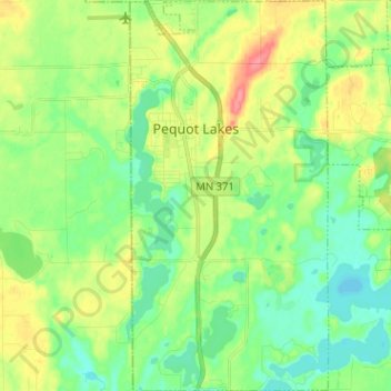
Name: Topografische Karte Pequot Lakes, Höhe, Relief.
Durchschnittliche Höhe: 383 m
Minimale Höhe: 360 m
Maximale Höhe: 425 m
Andere topografische Karten
Klicken Sie auf eine Karte, um ihre Topografie, ihre Höhe und ihr Relief anzuzeigen.
Bird Island
United States > Minnesota > Crow Wing County
Bird Island, Crow Wing County, Minnesota, United States
Durchschnittliche Höhe: 386 m
Brainerd
United States > Minnesota > Crow Wing County
Brainerd, Crow Wing County, Minnesota, 56401, United States
Durchschnittliche Höhe: 370 m
Nokay Lake
United States > Minnesota > Crow Wing County
Nokay Lake, Crow Wing County, Minnesota, United States
Durchschnittliche Höhe: 380 m
Emily Lake
United States > Minnesota > Crow Wing County > Emily
Emily Lake, Emily, Crow Wing County, Minnesota, United States
Durchschnittliche Höhe: 386 m
Cross Lake
United States > Minnesota > Crow Wing County > Crosslake
Cross Lake, Crosslake, Crow Wing County, Minnesota, 56442, United States
Durchschnittliche Höhe: 377 m
Breezy Point
United States > Minnesota > Crow Wing County
Breezy Point, Crow Wing County, Minnesota, United States
Durchschnittliche Höhe: 377 m
Ossawinnamakee Lake
United States > Minnesota > Crow Wing County > Breezy Point
Ossawinnamakee Lake, Breezy Point, Crow Wing County, Minnesota, United States
Durchschnittliche Höhe: 380 m
Boom Lake
United States > Minnesota > Crow Wing County > Brainerd
Boom Lake, Brainerd, Crow Wing County, Minnesota, United States
Durchschnittliche Höhe: 367 m
Platte Lake
United States > Minnesota > Crow Wing County
Platte Lake, Crow Wing County, Minnesota, United States
Durchschnittliche Höhe: 384 m
Ironton
United States > Minnesota > Crow Wing County
Ironton, Crow Wing County, Minnesota, United States
Durchschnittliche Höhe: 378 m
Brainerd
United States > Minnesota > Crow Wing County > Brainerd > Brainerd
Brainerd, Crow Wing County, Minnesota, 56401, United States
Durchschnittliche Höhe: 369 m