
Spenden
Rüste dich für dein nächstes Abenteuer:
Als Amazon-Partner verdient diese Website an qualifizierten Käufen, ohne zusätzliche Kosten für Sie.
Topografische Karte San Anselmo
Klicken Sie auf die Karte, um die Höhe anzuzeigen.
Spenden
Rüste dich für dein nächstes Abenteuer:
Als Amazon-Partner verdient diese Website an qualifizierten Käufen, ohne zusätzliche Kosten für Sie.
San Anselmo
San Anselmo (Spanish for '"Saint Anselm"') is an incorporated town in Marin County, California, United States. San Anselmo is located 1.5 miles (2.4 km) west of San Rafael, at an elevation of 46 feet (14 m). It is located about 20 miles (32 km) north of San Francisco. The town is bordered by San Rafael to the east, Fairfax to the west, and Ross to the south. Mount Tamalpais dominates the view to the south. The population was 12,830 at the 2020 census.
Spenden
Rüste dich für dein nächstes Abenteuer:
Als Amazon-Partner verdient diese Website an qualifizierten Käufen, ohne zusätzliche Kosten für Sie.
Über diese Karte
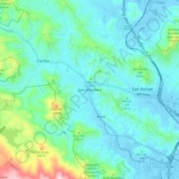
Name: Topografische Karte San Anselmo, Höhe, Relief.
Durchschnittliche Höhe: 99 m
Minimale Höhe: -3 m
Maximale Höhe: 550 m
Spenden
Rüste dich für dein nächstes Abenteuer:
Als Amazon-Partner verdient diese Website an qualifizierten Käufen, ohne zusätzliche Kosten für Sie.
Andere topografische Karten
Klicken Sie auf eine Karte, um ihre Topografie, ihre Höhe und ihr Relief anzuzeigen.
Corte Madera
United States > California > Marin County
Corte Madera (/ˈkɔːrtə məˈdɛrə/; Spanish for "Chop Wood") is an incorporated town in Marin County, California. Corte Madera is located 3.25 miles (5.2 km) south of San Rafael, at an elevation of 39 feet (12 m). The population was 10,222 at the 2020 census. The town was named after the Spanish…
Durchschnittliche Höhe: 52 m
Cascade Canyon Open Space Preserve
United States > California > Marin County > Fairfax > Manor
Durchschnittliche Höhe: 191 m
Spenden
Rüste dich für dein nächstes Abenteuer:
Als Amazon-Partner verdient diese Website an qualifizierten Käufen, ohne zusätzliche Kosten für Sie.
Tamalpais-Homestead Valley
United States > California > Marin County > Mill Valley
Durchschnittliche Höhe: 92 m
San Geronimo
United States > California > Marin County
San Geronimo (Spanish: San Gerónimo, meaning "St. Jerome") is a census-designated place (CDP) located in the San Geronimo Valley in Marin County, California in the United States. San Geronimo is located with Lagunitas-Forest Knolls to its west, Woodacre to its east, and 8 miles (13 km) southwest of downtown…
Durchschnittliche Höhe: 234 m