
Topografische Karte Cali
Interaktive Karte
Klicken Sie auf die Karte, um die Höhe anzuzeigen.
Über diese Karte
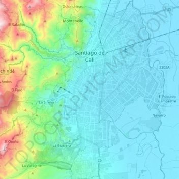
Name: Topografische Karte Cali, Höhe, Relief.
Ort: Cali, Sur, Valle del Cauca, RAP Pacífico, Colombia (3.33220 -76.59284 3.50623 -76.46133)
Durchschnittliche Höhe: 1.140 m
Minimale Höhe: 943 m
Maximale Höhe: 2.097 m
Under Köppen's climate classification, Cali features a dry-summer tropical savanna climate (Köppen climate classification: As). The Western Mountain Range rises from an average of 2,000 m (6,562 ft) above sea level in the northern part of the city to approximately 4,000 m (13,123 ft) to the south. Because of this variation in altitude, the weather in the northwest portion of the city is drier than in the southwest. The average annual precipitation varies between 900 to 1,800 mm (35 to 71 in) depending on the metropolitan zone for a citywide average of approximately 1,483 mm (58 in). Cali's average temperature is 24 °C (75 °F) with an average low temperature of 17.4 °C (63 °F) and a high of 30.5 °C (87 °F).
Andere topografische Karten
Klicken Sie auf eine Karte, um ihre Topografie, ihre Höhe und ihr Relief anzuzeigen.
La Paz
Colombia > Valle del Cauca > Cali
La Paz, Cali, Sur, Valle del Cauca, RAP Pacífico, Colombia
Durchschnittliche Höhe: 1.762 m
Comuna 19
Colombia > Valle del Cauca > Cali > Cali
Comuna 19, Cali, Sur, Valle del Cauca, RAP Pacífico, Colombia
Durchschnittliche Höhe: 1.027 m
Cali
Colombia > Valle del Cauca > Cali > Cali
Cali, Sur, Valle del Cauca, 760044, Colombia
Durchschnittliche Höhe: 1.343 m
Comuna 13
Colombia > Valle del Cauca > Cali > Cali
Comuna 13, Cali, Sur, Valle del Cauca, Colombia
Durchschnittliche Höhe: 950 m