
Topografische Karte Central-West
Interaktive Karte
Klicken Sie auf die Karte, um die Höhe anzuzeigen.
Über diese Karte
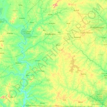
Name: Topografische Karte Central-West, Höhe, Relief.
Ort: Central-West, Burkina Faso (10.97200 -2.93171 12.84173 -1.30960)
Durchschnittliche Höhe: 302 m
Minimale Höhe: 237 m
Maximale Höhe: 550 m
Most of Burkino Faso is a wide plateau formed by riverine systems and is called falaise de Banfora. There are three major rivers, the Red Volta, Black Volta and White Volta, which cuts through different valleys. The climate is generally hot, with unreliable rains across different seasons. Gold and quartz are common minerals found across the country, while manganese deposits are also common. The dry season is usually from October to May and rains are common during the wet season from June to September. The soil texture is porous and hence the yield is also poor. The average elevation is around 200 m (660 ft) to 300 m (980 ft) above mean sea level. Among West African countries, Burkino Faso has the largest elephant population and the country is replete with game reserves. The southern regions are more tropical in nature and have Savannah and forests. The principal river is the Black Volta, that originates in the southern region and drains into Ghana. The areas near the rivers usually have flies like tsetse and similium, which are carriers of sleep sickness and river blindness. The average rainfall in the region is around 100 cm (39 in) compared to northern regions that receive only 25 cm (9.8 in) rainfall.
Andere topografische Karten
Klicken Sie auf eine Karte, um ihre Topografie, ihre Höhe und ihr Relief anzuzeigen.
Bobo-Dioulasso
Bobo-Dioulasso, Houet, Upper-Basins, Burkina Faso
Durchschnittliche Höhe: 388 m
Yo
Yo, Kassoum, Sourou, Boucle du Mouhoun, Burkina Faso
Durchschnittliche Höhe: 263 m
Koala
Koala, Nagréongo, Oubritenga, Central-Plateau, Burkina Faso
Durchschnittliche Höhe: 289 m
Koupéla
Koupéla, Sabou, Boulkiemdé, Central-West, Burkina Faso
Durchschnittliche Höhe: 293 m
Petebarabe
Petebarabe, Falagountou, Séno, Sahel, Burkina Faso
Durchschnittliche Höhe: 265 m
Fada N'Gourma
Fada N'Gourma, Gourma, East, Burkina Faso
Durchschnittliche Höhe: 302 m