
Topografische Karte Digos
Interaktive Karte
Klicken Sie auf die Karte, um die Höhe anzuzeigen.
Über diese Karte
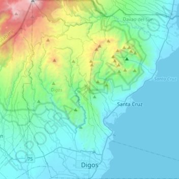
Name: Topografische Karte Digos, Höhe, Relief.
Ort: Digos, Davao del Sur, Davao Region, 8002, Philippines (6.72328 125.25544 6.98719 125.51924)
Durchschnittliche Höhe: 499 m
Minimale Höhe: -4 m
Maximale Höhe: 2.911 m
The land topography of Digos City ranges from hilly to mountainous in the north-northeast portion and flat and slightly rolling at the coastal barangays, while the urban area and the surrounding barangays in the south portion are generally flat. Generally, climate in Digos falls under the fourth type while wind direction is prevalent from northeast to southwest. On the other hand, rainfall is evenly distributed throughout the year wherein during the period from 1995 to 2000, there was no observed extreme dry or wet season.
Andere topografische Karten
Klicken Sie auf eine Karte, um ihre Topografie, ihre Höhe und ihr Relief anzuzeigen.
Solongvale
Philippines > Davao del Sur > Sulop
Solongvale, Sulop, Davao del Sur, Davao Region, 8009, Philippines
Durchschnittliche Höhe: 44 m
Santa Cruz
Santa Cruz, Davao del Sur, Davao Region, 8001, Philippines
Durchschnittliche Höhe: 360 m
Digos
Philippines > Davao del Sur > Digos
Digos, Davao del Sur, Davao Region, 8002, Philippines
Durchschnittliche Höhe: 152 m
Bansalan
Philippines > Davao del Sur > Bansalan
Bansalan, Davao del Sur, Davao Region, 8005, Philippines
Durchschnittliche Höhe: 157 m
Soong
Philippines > Davao del Sur > Digos > Soong
Soong, Digos, Davao del Sur, Davao Region, 8002, Philippines
Durchschnittliche Höhe: 280 m
Mount Apo
Philippines > Davao del Sur > Bansalan
Mount Apo, Bansalan, Davao del Sur, Davao Region, 8005, Philippines
Durchschnittliche Höhe: 2.416 m
Davao del Sur
Davao del Sur, Davao Region, Philippines
Durchschnittliche Höhe: 116 m