
Topografische Karte Bușteni
Interaktive Karte
Klicken Sie auf die Karte, um die Höhe anzuzeigen.
Bușteni
Bușteni (Romanian pronunciation: [buʃˈtenʲ]) is a small mountain town in the north of Prahova County, Muntenia, Romania. It is located in the Prahova Valley, at the bottom of the Bucegi Mountains, that have a maximum altitude of 2,505 m (8,219 ft). Its name literally means tree-logs in Romanian. One village, Poiana Țapului, is administratively part of the town, formerly a separate commune prior to 1950. According to the 2011 census, it has 8,894 inhabitants.
Über diese Karte
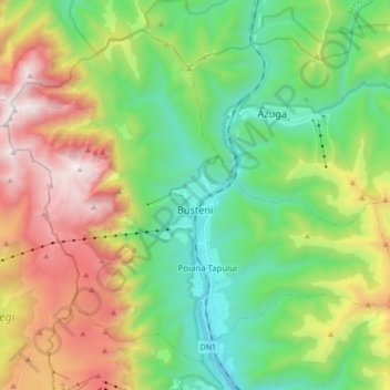
Name: Topografische Karte Bușteni, Höhe, Relief.
Ort: Bușteni, Prahova, Romania (45.36783 25.45256 45.47040 25.62365)
Durchschnittliche Höhe: 1.419 m
Minimale Höhe: 807 m
Maximale Höhe: 2.500 m
Andere topografische Karten
Klicken Sie auf eine Karte, um ihre Topografie, ihre Höhe und ihr Relief anzuzeigen.