
Topografische Karte City of Schenectady
Interaktive Karte
Klicken Sie auf die Karte, um die Höhe anzuzeigen.
Über diese Karte
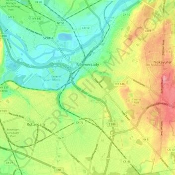
Name: Topografische Karte City of Schenectady, Höhe, Relief.
Durchschnittliche Höhe: 100 m
Minimale Höhe: 60 m
Maximale Höhe: 154 m
Andere topografische Karten
Klicken Sie auf eine Karte, um ihre Topografie, ihre Höhe und ihr Relief anzuzeigen.
Town of Rotterdam
United States > New York > Schenectady County
Town of Rotterdam, Schenectady County, New York, United States
Durchschnittliche Höhe: 132 m
Village of Delanson
United States > New York > Schenectady County > Town of Duanesburg
Village of Delanson, Town of Duanesburg, Schenectady County, New York, 12053, United States
Durchschnittliche Höhe: 290 m
Town of Niskayuna
United States > New York > Schenectady County
Town of Niskayuna, Schenectady County, New York, 12309, United States
Durchschnittliche Höhe: 101 m
Glenville
United States > New York > Schenectady County > Glenville
Glenville, Town of Glenville, Schenectady County, New York, 12325, United States
Durchschnittliche Höhe: 107 m