
Topografische Karte Nichols
Interaktive Karte
Klicken Sie auf die Karte, um die Höhe anzuzeigen.
Über diese Karte
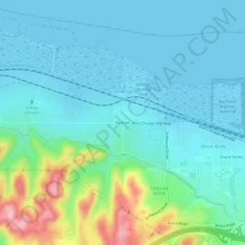
Name: Topografische Karte Nichols, Höhe, Relief.
Durchschnittliche Höhe: 38 m
Minimale Höhe: -2 m
Maximale Höhe: 183 m
Andere topografische Karten
Klicken Sie auf eine Karte, um ihre Topografie, ihre Höhe und ihr Relief anzuzeigen.
McAvoy
United States > California > Contra Costa County > Bay Point
McAvoy, Bay Point, Contra Costa County, California, United States
Durchschnittliche Höhe: 20 m
Shore Acres
United States > California > Contra Costa County > Bay Point
Shore Acres, Bay Point, Contra Costa County, CAL Fire Northern Region, California, United States
Durchschnittliche Höhe: 31 m