
Topografische Karte High Peaks
Interaktive Karte
Klicken Sie auf die Karte, um die Höhe anzuzeigen.
Über diese Karte
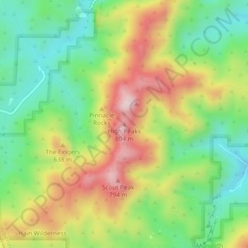
Name: Topografische Karte High Peaks, Höhe, Relief.
Ort: High Peaks, San Benito County, California, United States (36.48574 -121.19831 36.48584 -121.19821)
Durchschnittliche Höhe: 565 m
Minimale Höhe: 393 m
Maximale Höhe: 798 m
Andere topografische Karten
Klicken Sie auf eine Karte, um ihre Topografie, ihre Höhe und ihr Relief anzuzeigen.
Pinnacles National Park
United States > California > San Benito County
Pinnacles National Park, San Benito County, California, United States
Durchschnittliche Höhe: 495 m
Llanada
United States > California > San Benito County
Llanada, San Benito County, California, United States
Durchschnittliche Höhe: 490 m
Paicines
United States > California > San Benito County
Paicines, San Benito County, California, United States
Durchschnittliche Höhe: 237 m
Hollister
United States > California > San Benito County
Hollister, San Benito County, California, 95023, United States
Durchschnittliche Höhe: 92 m
Laguna Mountain
United States > California > San Benito County
Laguna Mountain, San Benito County, California, United States
Durchschnittliche Höhe: 1.131 m
San Juan Bautista
United States > California > San Benito County
San Juan Bautista, San Benito County, California, 95045, United States
Durchschnittliche Höhe: 72 m
Fremont Peak State Park
United States > California > San Benito County
Fremont Peak State Park, San Benito County, California, United States
Durchschnittliche Höhe: 705 m